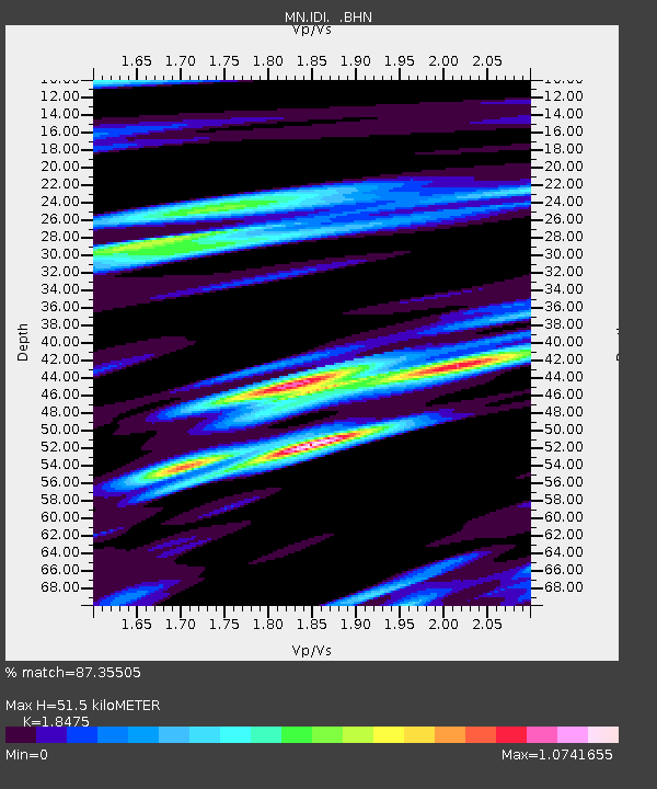
IDI Anogia, Greece - Earthquake Result Viewer

Earthquake location: Southwest Of Sumatra, Indonesia
Earthquake latitude/longitude: -6.2/103.1
Earthquake time(UTC): 2005/05/10 (130) 01:09:05 GMT
Earthquake Depth: 17 km
Earthquake Magnitude: 5.9 MB, 6.4 MS, 6.2 MW, 6.2 MW
Earthquake Catalog/Contributor: WHDF/NEIC
Network: MN MEDNET Project
Station: IDI Anogia, Greece
Lat/Lon: 35.29 N/24.89 E
Elevation: 750 m
Distance: 84.0 deg
Az: 306.363 deg
Baz: 101.87 deg
Ray Param: 0.045742456
Estimated Moho Depth: 51.5 km
Estimated Crust Vp/Vs: 1.85
Assumed Crust Vp: 5.627 km/s
Estimated Crust Vs: 3.046 km/s
Estimated Crust Poisson's Ratio: 0.29
Radial Match: 87.35505 %
Radial Bump: 400
Transverse Match: 76.90804 %
Transverse Bump: 400
SOD ConfigId: 2455
Insert Time: 2010-03-08 17:09:36.652 +0000
GWidth: 2.5
Max Bumps: 400
Tol: 0.001

Signal To Noise

ChannelStoNSTALTA
MN:IDI: :BHN:20050510T01:21:03.222009Z2.01431941.709479E-78.4866336E-8
MN:IDI: :BHE:20050510T01:21:03.222009Z8.6645715.160513E-75.9558783E-8
MN:IDI: :BHZ:20050510T01:21:03.222009Z18.1626131.2641856E-66.960373E-8
Arrivals
Ps7.9 SECOND
PpPs26 SECOND
PsPs/PpSs33 SECOND