You are here: Home > Network List > UU - University of Utah Regional Network Stations List
> Station FORU South Mineral Mountains, UT, USA > Earthquake Result Viewer
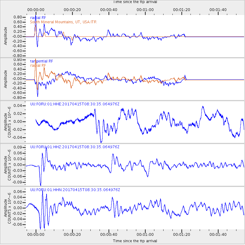
FORU South Mineral Mountains, UT, USA - Earthquake Result Viewer
*The percent match for this event was below the threshold and hence no stack was calculated.
| Earthquake location: |
Chile-Argentina Border Region |
| Earthquake latitude/longitude: |
-23.2/-67.7 |
| Earthquake time(UTC): |
2017/04/15 (105) 08:19:41 GMT |
| Earthquake Depth: |
135 km |
| Earthquake Magnitude: |
6.2 Mww |
| Earthquake Catalog/Contributor: |
NEIC PDE/us |
|
| Network: |
UU University of Utah Regional Network |
| Station: |
FORU South Mineral Mountains, UT, USA |
| Lat/Lon: |
38.46 N/112.86 W |
| Elevation: |
1840 m |
|
| Distance: |
74.6 deg |
| Az: |
324.694 deg |
| Baz: |
137.379 deg |
| Ray Param: |
$rayparam |
*The percent match for this event was below the threshold and hence was not used in the summary stack. |
|
| Radial Match: |
65.98695 % |
| Radial Bump: |
400 |
| Transverse Match: |
54.15355 % |
| Transverse Bump: |
400 |
| SOD ConfigId: |
2028011 |
| Insert Time: |
2017-04-29 08:36:27.032 +0000 |
| GWidth: |
2.5 |
| Max Bumps: |
400 |
| Tol: |
0.001 |
|
Signal To Noise
| Channel | StoN | STA | LTA |
| UU:FORU:01:HHZ:20170415T08:30:35.064976Z | 8.524331 | 4.0358493E-8 | 4.7345057E-9 |
| UU:FORU:01:HHN:20170415T08:30:35.064976Z | 5.380159 | 3.6130402E-8 | 6.71549E-9 |
| UU:FORU:01:HHE:20170415T08:30:35.064976Z | 2.8826468 | 2.1180101E-8 | 7.3474493E-9 |
| Arrivals |
| Ps | |
| PpPs | |
| PsPs/PpSs | |


