IDI Anogia, Greece - Earthquake Result Viewer
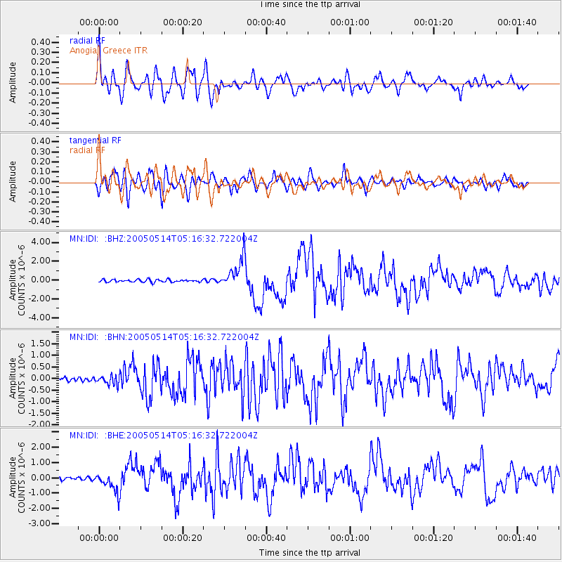
Earthquake location: Northern Sumatra, Indonesia
Earthquake latitude/longitude: 0.6/98.5
Earthquake time(UTC): 2005/05/14 (134) 05:05:18 GMT
Earthquake Depth: 34 km
Earthquake Magnitude: 6.4 MB, 6.8 MS, 6.8 MW, 6.8 MW
Earthquake Catalog/Contributor: WHDF/NEIC
Network: MN MEDNET Project
Station: IDI Anogia, Greece
Lat/Lon: 35.29 N/24.89 E
Elevation: 750 m
Distance: 76.3 deg
Az: 306.125 deg
Baz: 99.142 deg
Ray Param: 0.051054172
Estimated Moho Depth: 44.5 km
Estimated Crust Vp/Vs: 1.84
Assumed Crust Vp: 5.627 km/s
Estimated Crust Vs: 3.062 km/s
Estimated Crust Poisson's Ratio: 0.29
Radial Match: 88.803375 %
Radial Bump: 400
Transverse Match: 80.66219 %
Transverse Bump: 400
SOD ConfigId: 2455
Insert Time: 2010-03-08 17:09:37.801 +0000
GWidth: 2.5
Max Bumps: 400
Tol: 0.001

Signal To Noise

ChannelStoNSTALTA
MN:IDI: :BHN:20050514T05:16:32.722004Z2.61107281.9052182E-77.296688E-8
MN:IDI: :BHE:20050514T05:16:32.722004Z7.51522646.4421437E-78.572122E-8
MN:IDI: :BHZ:20050514T05:16:32.722004Z12.2901281.616119E-61.3149733E-7
Arrivals
Ps6.8 SECOND
PpPs22 SECOND
PsPs/PpSs29 SECOND