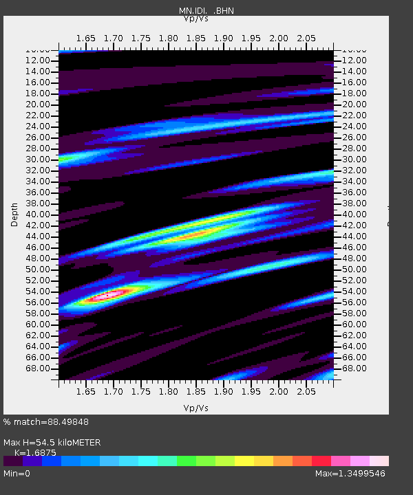
IDI Anogia, Greece - Earthquake Result Viewer

Earthquake location: Northern Sumatra, Indonesia
Earthquake latitude/longitude: 1.8/97.1
Earthquake time(UTC): 2005/07/05 (186) 01:52:02 GMT
Earthquake Depth: 21 km
Earthquake Magnitude: 6.2 MB, 6.8 MS, 6.7 MW, 6.6 MW
Earthquake Catalog/Contributor: WHDF/NEIC
Network: MN MEDNET Project
Station: IDI Anogia, Greece
Lat/Lon: 35.29 N/24.89 E
Elevation: 750 m
Distance: 74.4 deg
Az: 306.05 deg
Baz: 98.958 deg
Ray Param: 0.05230876
Estimated Moho Depth: 54.5 km
Estimated Crust Vp/Vs: 1.69
Assumed Crust Vp: 5.627 km/s
Estimated Crust Vs: 3.334 km/s
Estimated Crust Poisson's Ratio: 0.23
Radial Match: 88.49848 %
Radial Bump: 400
Transverse Match: 82.911026 %
Transverse Bump: 400
SOD ConfigId: 2475
Insert Time: 2010-03-08 17:09:39.245 +0000
GWidth: 2.5
Max Bumps: 400
Tol: 0.001

Signal To Noise

ChannelStoNSTALTA
MN:IDI: :BHN:20050705T02:03:08.246997Z1.71746221.4863576E-78.654383E-8
MN:IDI: :BHE:20050705T02:03:08.246997Z7.88118126.3659735E-78.0774356E-8
MN:IDI: :BHZ:20050705T02:03:08.246997Z11.037561.357807E-61.2301696E-7
Arrivals
Ps6.8 SECOND
PpPs25 SECOND
PsPs/PpSs32 SECOND