You are here: Home > Network List > UU - University of Utah Regional Network Stations List
> Station KNB Kanab, UT, USA > Earthquake Result Viewer
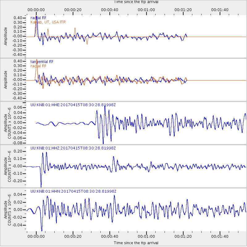
KNB Kanab, UT, USA - Earthquake Result Viewer
| Earthquake location: |
Chile-Argentina Border Region |
| Earthquake latitude/longitude: |
-23.2/-67.7 |
| Earthquake time(UTC): |
2017/04/15 (105) 08:19:41 GMT |
| Earthquake Depth: |
135 km |
| Earthquake Magnitude: |
6.2 Mww |
| Earthquake Catalog/Contributor: |
NEIC PDE/us |
|
| Network: |
UU University of Utah Regional Network |
| Station: |
KNB Kanab, UT, USA |
| Lat/Lon: |
37.02 N/112.82 W |
| Elevation: |
1715 m |
|
| Distance: |
73.5 deg |
| Az: |
323.701 deg |
| Baz: |
137.13 deg |
| Ray Param: |
0.05261498 |
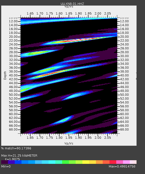
| Estimated Moho Depth: |
21.25 km |
| Estimated Crust Vp/Vs: |
1.91 |
| Assumed Crust Vp: |
6.194 km/s |
| Estimated Crust Vs: |
3.247 km/s |
| Estimated Crust Poisson's Ratio: |
0.31 |
|
| Radial Match: |
90.17396 % |
| Radial Bump: |
351 |
| Transverse Match: |
85.31568 % |
| Transverse Bump: |
400 |
| SOD ConfigId: |
2028011 |
| Insert Time: |
2017-04-29 08:36:32.916 +0000 |
| GWidth: |
2.5 |
| Max Bumps: |
400 |
| Tol: |
0.001 |
|
Signal To Noise
| Channel | StoN | STA | LTA |
| UU:KNB:01:HHZ:20170415T08:30:28.81998Z | 19.364435 | 9.79369E-8 | 5.057565E-9 |
| UU:KNB:01:HHN:20170415T08:30:28.81998Z | 5.5281415 | 2.0309379E-8 | 3.6738168E-9 |
| UU:KNB:01:HHE:20170415T08:30:28.81998Z | 7.1495104 | 2.604304E-8 | 3.6426324E-9 |
| Arrivals |
| Ps | 3.2 SECOND |
| PpPs | 9.7 SECOND |
| PsPs/PpSs | 13 SECOND |


