IDI Anogia, Greece - Earthquake Result Viewer
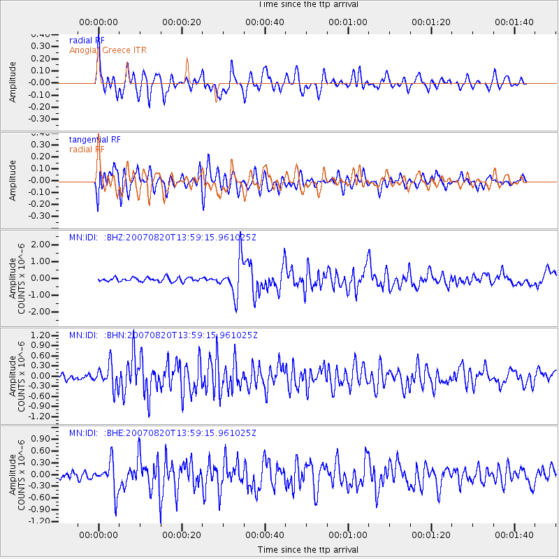
Earthquake location: Philippine Islands Region
Earthquake latitude/longitude: 6.1/127.4
Earthquake time(UTC): 2007/08/20 (232) 13:46:17 GMT
Earthquake Depth: 8.0 km
Earthquake Magnitude: 6.4 MB, 6.2 MS, 6.4 MW, 6.5 ME
Earthquake Catalog/Contributor: WHDF/NEIC
Network: MN MEDNET Project
Station: IDI Anogia, Greece
Lat/Lon: 35.29 N/24.89 E
Elevation: 750 m
Distance: 96.6 deg
Az: 306.482 deg
Baz: 77.765 deg
Ray Param: 0.040469024
Estimated Moho Depth: 13.75 km
Estimated Crust Vp/Vs: 1.99
Assumed Crust Vp: 5.627 km/s
Estimated Crust Vs: 2.831 km/s
Estimated Crust Poisson's Ratio: 0.33
Radial Match: 84.112114 %
Radial Bump: 400
Transverse Match: 77.58899 %
Transverse Bump: 400
SOD ConfigId: 2564
Insert Time: 2010-03-08 17:09:50.800 +0000
GWidth: 2.5
Max Bumps: 400
Tol: 0.001

Signal To Noise

ChannelStoNSTALTA
MN:IDI: :BHN:20070820T13:59:15.961025Z5.00168373.5621804E-77.1219624E-8
MN:IDI: :BHE:20070820T13:59:15.961025Z5.0363543.9683908E-77.879491E-8
MN:IDI: :BHZ:20070820T13:59:15.961025Z9.5042051.1158397E-61.1740485E-7
Arrivals
Ps2.4 SECOND
PpPs7.2 SECOND
PsPs/PpSs9.6 SECOND