You are here: Home > Network List > MN - MEDNET Project Stations List
> Station IDI Anogia, Greece > Earthquake Result Viewer
IDI Anogia, Greece - Earthquake Result Viewer
| Earthquake location: |
Java, Indonesia |
| Earthquake latitude/longitude: |
-5.9/107.7 |
| Earthquake time(UTC): |
2007/08/08 (220) 17:04:57 GMT |
| Earthquake Depth: |
291 km |
| Earthquake Magnitude: |
6.1 MB |
| Earthquake Catalog/Contributor: |
WHDF/NEIC |
|
| Network: |
MN MEDNET Project |
| Station: |
IDI Anogia, Greece |
| Lat/Lon: |
35.29 N/24.89 E |
| Elevation: |
750 m |
|
| Distance: |
87.5 deg |
| Az: |
305.672 deg |
| Baz: |
98.965 deg |
| Ray Param: |
0.042540506 |
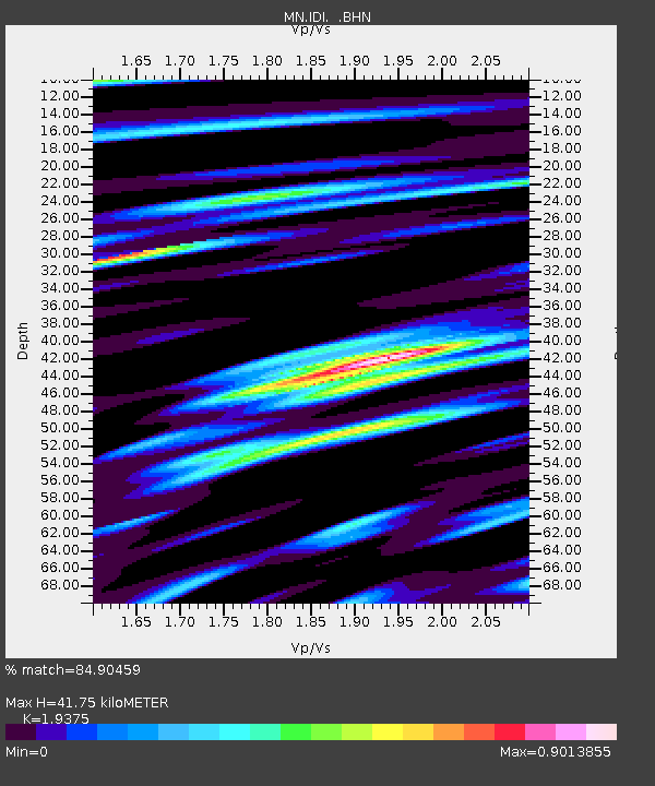
| Estimated Moho Depth: |
41.75 km |
| Estimated Crust Vp/Vs: |
1.94 |
| Assumed Crust Vp: |
5.627 km/s |
| Estimated Crust Vs: |
2.904 km/s |
| Estimated Crust Poisson's Ratio: |
0.32 |
|
| Radial Match: |
84.90459 % |
| Radial Bump: |
400 |
| Transverse Match: |
76.88127 % |
| Transverse Bump: |
400 |
| SOD ConfigId: |
2564 |
| Insert Time: |
2010-03-08 17:09:52.061 +0000 |
| GWidth: |
2.5 |
| Max Bumps: |
400 |
| Tol: |
0.001 |
|
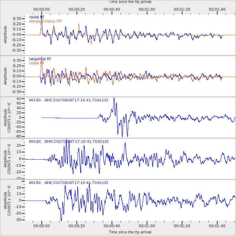
Signal To Noise
| Channel | StoN | STA | LTA |
| MN:IDI: :BHN:20070808T17:16:41.709019Z | 13.046273 | 9.843693E-7 | 7.545214E-8 |
| MN:IDI: :BHE:20070808T17:16:41.709019Z | 12.463718 | 2.0067816E-6 | 1.6100986E-7 |
| MN:IDI: :BHZ:20070808T17:16:41.709019Z | 14.111294 | 5.8490073E-6 | 4.144912E-7 |
| Arrivals |
| Ps | 7.1 SECOND |
| PpPs | 21 SECOND |
| PsPs/PpSs | 29 SECOND |


