You are here: Home > Network List > MN - MEDNET Project Stations List
> Station IDI Anogia, Greece > Earthquake Result Viewer
IDI Anogia, Greece - Earthquake Result Viewer

| Earthquake location: |
South Of Java, Indonesia |
| Earthquake latitude/longitude: |
-10.5/108.1 |
| Earthquake time(UTC): |
2007/06/26 (177) 22:23:03 GMT |
| Earthquake Depth: |
10 km |
| Earthquake Magnitude: |
5.8 MB, 5.6 MS, 6.0 MW, 5.9 MW |
| Earthquake Catalog/Contributor: |
WHDF/NEIC |
|
| Network: |
MN MEDNET Project |
| Station: |
IDI Anogia, Greece |
| Lat/Lon: |
35.29 N/24.89 E |
| Elevation: |
750 m |
|
| Distance: |
90.6 deg |
| Az: |
305.663 deg |
| Baz: |
102.381 deg |
| Ray Param: |
0.041665368 |
| Estimated Moho Depth: |
42.5 km |
| Estimated Crust Vp/Vs: |
1.89 |
| Assumed Crust Vp: |
5.627 km/s |
| Estimated Crust Vs: |
2.973 km/s |
| Estimated Crust Poisson's Ratio: |
0.31 |
|
| Radial Match: |
87.72315 % |
| Radial Bump: |
400 |
| Transverse Match: |
82.63026 % |
| Transverse Bump: |
400 |
| SOD ConfigId: |
2564 |
| Insert Time: |
2010-03-08 17:09:56.878 +0000 |
| GWidth: |
2.5 |
| Max Bumps: |
400 |
| Tol: |
0.001 |
|
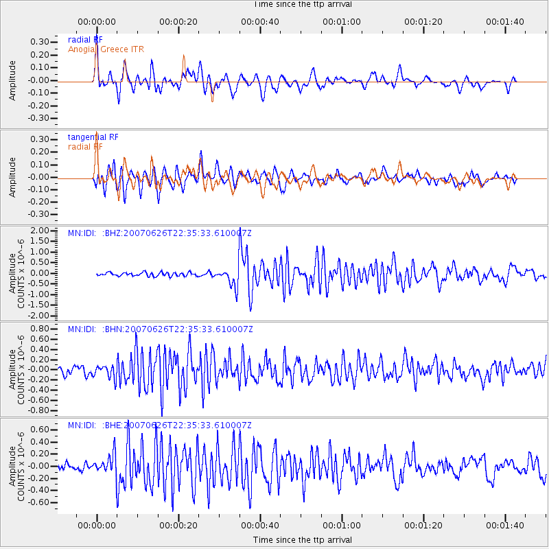
Signal To Noise
| Channel | StoN | STA | LTA |
| MN:IDI: :BHN:20070626T22:35:33.610007Z | 1.9374447 | 1.2613336E-7 | 6.510295E-8 |
| MN:IDI: :BHE:20070626T22:35:33.610007Z | 3.5596802 | 1.6820245E-7 | 4.7252122E-8 |
| MN:IDI: :BHZ:20070626T22:35:33.610007Z | 5.818247 | 4.6709343E-7 | 8.0280785E-8 |
| Arrivals |
| Ps | 6.8 SECOND |
| PpPs | 22 SECOND |
| PsPs/PpSs | 28 SECOND |


