You are here: Home > Network List > GS - US Geological Survey Networks Stations List
> Station OK052 Battle Ridge Rd, NW of Cushing, OK, USA > Earthquake Result Viewer
OK052 Battle Ridge Rd, NW of Cushing, OK, USA - Earthquake Result Viewer
| Earthquake location: |
Puerto Rico Region |
| Earthquake latitude/longitude: |
17.9/-66.8 |
| Earthquake time(UTC): |
2020/01/07 (007) 08:24:26 GMT |
| Earthquake Depth: |
10 km |
| Earthquake Magnitude: |
6.4 mww |
| Earthquake Catalog/Contributor: |
NEIC PDE/us |
|
| Network: |
GS US Geological Survey Networks |
| Station: |
OK052 Battle Ridge Rd, NW of Cushing, OK, USA |
| Lat/Lon: |
35.99 N/96.80 W |
| Elevation: |
259 m |
|
| Distance: |
32.0 deg |
| Az: |
310.182 deg |
| Baz: |
116.235 deg |
| Ray Param: |
0.07883543 |
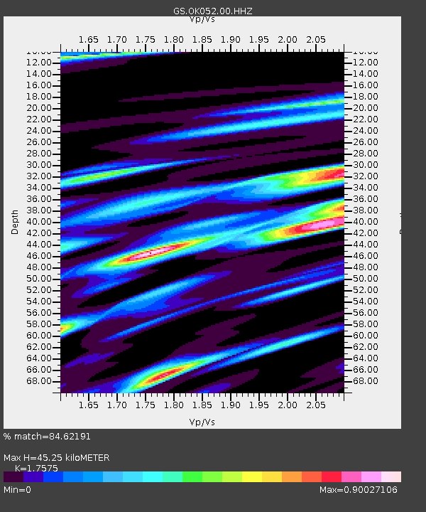
| Estimated Moho Depth: |
45.25 km |
| Estimated Crust Vp/Vs: |
1.76 |
| Assumed Crust Vp: |
6.426 km/s |
| Estimated Crust Vs: |
3.656 km/s |
| Estimated Crust Poisson's Ratio: |
0.26 |
|
| Radial Match: |
84.62191 % |
| Radial Bump: |
324 |
| Transverse Match: |
53.357742 % |
| Transverse Bump: |
371 |
| SOD ConfigId: |
20465011 |
| Insert Time: |
2020-01-21 08:38:08.094 +0000 |
| GWidth: |
2.5 |
| Max Bumps: |
400 |
| Tol: |
0.001 |
|

Signal To Noise
| Channel | StoN | STA | LTA |
| GS:OK052:00:HHZ:20200107T08:30:22.59001Z | 10.137519 | 2.4792362E-6 | 2.4456045E-7 |
| GS:OK052:00:HH1:20200107T08:30:22.59001Z | 1.8651106 | 8.032374E-7 | 4.3066476E-7 |
| GS:OK052:00:HH2:20200107T08:30:22.59001Z | 5.377811 | 1.5020967E-6 | 2.7931378E-7 |
| Arrivals |
| Ps | 5.8 SECOND |
| PpPs | 18 SECOND |
| PsPs/PpSs | 24 SECOND |


