You are here: Home > Network List > MN - MEDNET Project Stations List
> Station IDI Anogia, Greece > Earthquake Result Viewer
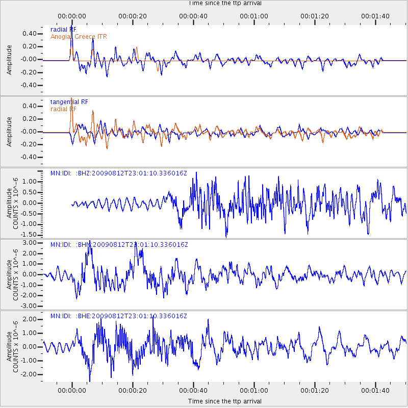
IDI Anogia, Greece - Earthquake Result Viewer

| Earthquake location: |
Southeast Of Honshu, Japan |
| Earthquake latitude/longitude: |
32.8/140.4 |
| Earthquake time(UTC): |
2009/08/12 (224) 22:48:51 GMT |
| Earthquake Depth: |
53 km |
| Earthquake Magnitude: |
6.2 MB, 6.6 MW, 6.6 MW |
| Earthquake Catalog/Contributor: |
WHDF/NEIC |
|
| Network: |
MN MEDNET Project |
| Station: |
IDI Anogia, Greece |
| Lat/Lon: |
35.29 N/24.89 E |
| Elevation: |
750 m |
|
| Distance: |
89.2 deg |
| Az: |
312.402 deg |
| Baz: |
49.467 deg |
| Ray Param: |
0.041922126 |
| Estimated Moho Depth: |
44.75 km |
| Estimated Crust Vp/Vs: |
1.88 |
| Assumed Crust Vp: |
5.627 km/s |
| Estimated Crust Vs: |
2.989 km/s |
| Estimated Crust Poisson's Ratio: |
0.30 |
|
| Radial Match: |
82.983665 % |
| Radial Bump: |
400 |
| Transverse Match: |
79.604004 % |
| Transverse Bump: |
400 |
| SOD ConfigId: |
2622 |
| Insert Time: |
2010-03-08 17:10:04.097 +0000 |
| GWidth: |
2.5 |
| Max Bumps: |
400 |
| Tol: |
0.001 |
|
Signal To Noise
| Channel | StoN | STA | LTA |
| MN:IDI: :BHN:20090812T23:01:10.336016Z | 6.289423 | 1.0833659E-6 | 1.7225203E-7 |
| MN:IDI: :BHE:20090812T23:01:10.336016Z | 2.758798 | 5.8334507E-7 | 2.11449E-7 |
| MN:IDI: :BHZ:20090812T23:01:10.336016Z | 1.8603278 | 2.7743542E-7 | 1.4913255E-7 |
| Arrivals |
| Ps | 7.1 SECOND |
| PpPs | 23 SECOND |
| PsPs/PpSs | 30 SECOND |


