You are here: Home > Network List > IW - Intermountain West Stations List
> Station MOOW Moose Ponds, Wyoming, USA > Earthquake Result Viewer
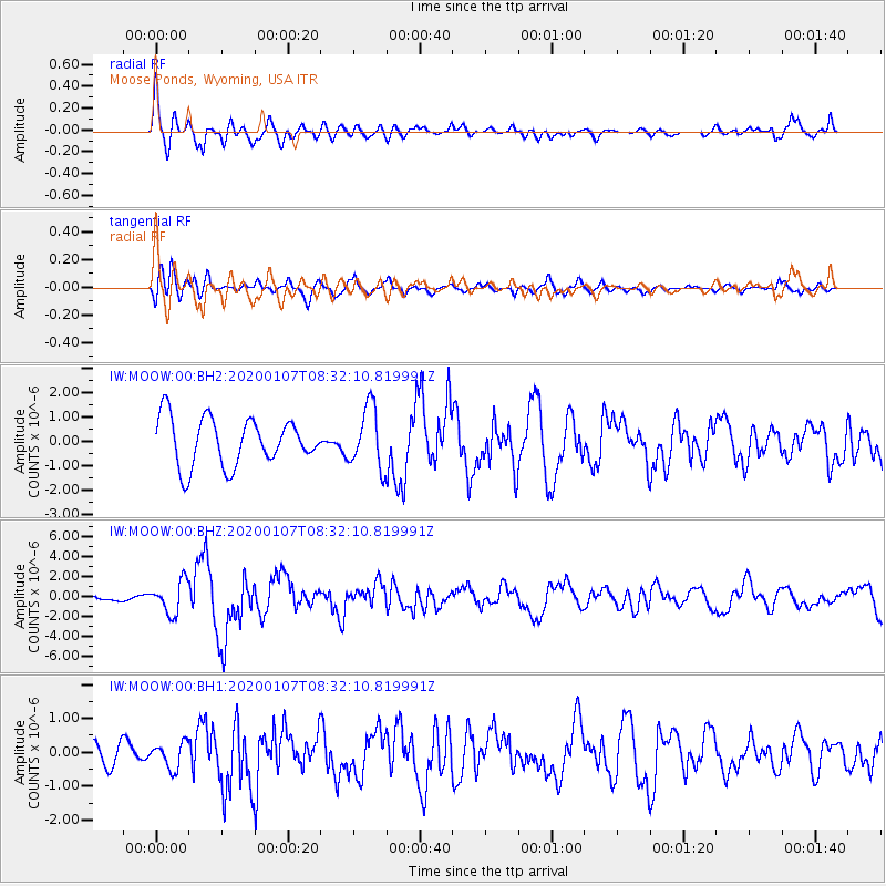
MOOW Moose Ponds, Wyoming, USA - Earthquake Result Viewer
*The percent match for this event was below the threshold and hence no stack was calculated.
| Earthquake location: |
Puerto Rico Region |
| Earthquake latitude/longitude: |
17.9/-66.8 |
| Earthquake time(UTC): |
2020/01/07 (007) 08:24:26 GMT |
| Earthquake Depth: |
10 km |
| Earthquake Magnitude: |
6.4 mww |
| Earthquake Catalog/Contributor: |
NEIC PDE/us |
|
| Network: |
IW Intermountain West |
| Station: |
MOOW Moose Ponds, Wyoming, USA |
| Lat/Lon: |
43.75 N/110.74 W |
| Elevation: |
2128 m |
|
| Distance: |
45.0 deg |
| Az: |
314.638 deg |
| Baz: |
110.797 deg |
| Ray Param: |
$rayparam |
*The percent match for this event was below the threshold and hence was not used in the summary stack. |
|
| Radial Match: |
76.608444 % |
| Radial Bump: |
400 |
| Transverse Match: |
65.38691 % |
| Transverse Bump: |
400 |
| SOD ConfigId: |
20465011 |
| Insert Time: |
2020-01-21 08:39:18.925 +0000 |
| GWidth: |
2.5 |
| Max Bumps: |
400 |
| Tol: |
0.001 |
|
Signal To Noise
| Channel | StoN | STA | LTA |
| IW:MOOW:00:BHZ:20200107T08:32:10.819991Z | 1.8816266 | 1.5878319E-6 | 8.438613E-7 |
| IW:MOOW:00:BH1:20200107T08:32:10.819991Z | 1.3218293 | 3.7667522E-7 | 2.849651E-7 |
| IW:MOOW:00:BH2:20200107T08:32:10.819991Z | 1.2864606 | 1.25187E-6 | 9.731118E-7 |
| Arrivals |
| Ps | |
| PpPs | |
| PsPs/PpSs | |


