You are here: Home > Network List > MN - MEDNET Project Stations List
> Station IDI Anogia, Greece > Earthquake Result Viewer
IDI Anogia, Greece - Earthquake Result Viewer

| Earthquake location: |
Ryukyu Islands, Japan |
| Earthquake latitude/longitude: |
29.2/129.8 |
| Earthquake time(UTC): |
2009/10/30 (303) 07:03:39 GMT |
| Earthquake Depth: |
34 km |
| Earthquake Magnitude: |
6.3 MB, 6.8 MS, 6.8 MW, 6.8 MW |
| Earthquake Catalog/Contributor: |
WHDF/NEIC |
|
| Network: |
MN MEDNET Project |
| Station: |
IDI Anogia, Greece |
| Lat/Lon: |
35.29 N/24.89 E |
| Elevation: |
750 m |
|
| Distance: |
84.5 deg |
| Az: |
307.417 deg |
| Baz: |
58.068 deg |
| Ray Param: |
0.04537852 |
| Estimated Moho Depth: |
40.5 km |
| Estimated Crust Vp/Vs: |
1.97 |
| Assumed Crust Vp: |
5.627 km/s |
| Estimated Crust Vs: |
2.864 km/s |
| Estimated Crust Poisson's Ratio: |
0.33 |
|
| Radial Match: |
83.51266 % |
| Radial Bump: |
400 |
| Transverse Match: |
81.825836 % |
| Transverse Bump: |
400 |
| SOD ConfigId: |
2622 |
| Insert Time: |
2010-03-08 17:10:09.098 +0000 |
| GWidth: |
2.5 |
| Max Bumps: |
400 |
| Tol: |
0.001 |
|
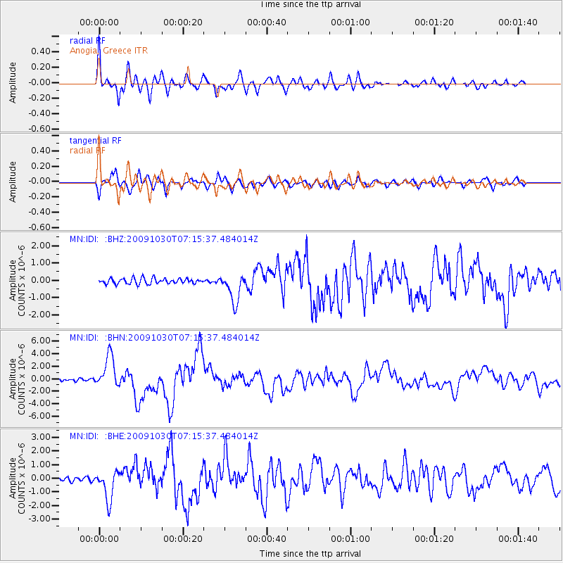
Signal To Noise
| Channel | StoN | STA | LTA |
| MN:IDI: :BHN:20091030T07:15:37.484014Z | 13.5473 | 2.664138E-6 | 1.9665453E-7 |
| MN:IDI: :BHE:20091030T07:15:37.484014Z | 9.075672 | 1.1350933E-6 | 1.2506989E-7 |
| MN:IDI: :BHZ:20091030T07:15:37.484014Z | 5.4898386 | 8.537808E-7 | 1.5552021E-7 |
| Arrivals |
| Ps | 7.1 SECOND |
| PpPs | 21 SECOND |
| PsPs/PpSs | 28 SECOND |


