You are here: Home > Network List > N4 - Central and EAstern US Network Stations List
> Station U38B Mount Pleasant Farm, Gravette, AR, USA > Earthquake Result Viewer
U38B Mount Pleasant Farm, Gravette, AR, USA - Earthquake Result Viewer
| Earthquake location: |
Puerto Rico Region |
| Earthquake latitude/longitude: |
17.9/-66.8 |
| Earthquake time(UTC): |
2020/01/07 (007) 08:24:26 GMT |
| Earthquake Depth: |
10 km |
| Earthquake Magnitude: |
6.4 mww |
| Earthquake Catalog/Contributor: |
NEIC PDE/us |
|
| Network: |
N4 Central and EAstern US Network |
| Station: |
U38B Mount Pleasant Farm, Gravette, AR, USA |
| Lat/Lon: |
36.44 N/94.39 W |
| Elevation: |
389 m |
|
| Distance: |
30.5 deg |
| Az: |
312.706 deg |
| Baz: |
119.815 deg |
| Ray Param: |
0.079394214 |
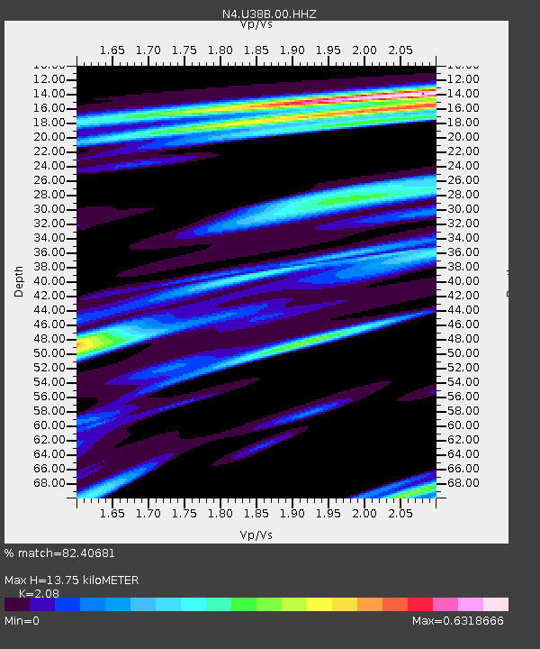
| Estimated Moho Depth: |
13.75 km |
| Estimated Crust Vp/Vs: |
2.08 |
| Assumed Crust Vp: |
6.53 km/s |
| Estimated Crust Vs: |
3.14 km/s |
| Estimated Crust Poisson's Ratio: |
0.35 |
|
| Radial Match: |
82.40681 % |
| Radial Bump: |
400 |
| Transverse Match: |
56.517128 % |
| Transverse Bump: |
400 |
| SOD ConfigId: |
20465011 |
| Insert Time: |
2020-01-21 08:40:34.028 +0000 |
| GWidth: |
2.5 |
| Max Bumps: |
400 |
| Tol: |
0.001 |
|

Signal To Noise
| Channel | StoN | STA | LTA |
| N4:U38B:00:HHZ:20200107T08:30:09.270003Z | 3.1501358 | 1.6288227E-6 | 5.170643E-7 |
| N4:U38B:00:HH1:20200107T08:30:09.270003Z | 1.543563 | 7.9776356E-7 | 5.1683253E-7 |
| N4:U38B:00:HH2:20200107T08:30:09.270003Z | 2.6518438 | 9.559795E-7 | 3.6049616E-7 |
| Arrivals |
| Ps | 2.4 SECOND |
| PpPs | 6.0 SECOND |
| PsPs/PpSs | 8.5 SECOND |


