You are here: Home > Network List > O2 - Oklahoma Consolidated Temporary Seismic Networks Stations List
> Station KS13 South Haven SW Station, Kansas > Earthquake Result Viewer
KS13 South Haven SW Station, Kansas - Earthquake Result Viewer
| Earthquake location: |
Puerto Rico Region |
| Earthquake latitude/longitude: |
17.9/-66.8 |
| Earthquake time(UTC): |
2020/01/07 (007) 08:24:26 GMT |
| Earthquake Depth: |
10 km |
| Earthquake Magnitude: |
6.4 mww |
| Earthquake Catalog/Contributor: |
NEIC PDE/us |
|
| Network: |
O2 Oklahoma Consolidated Temporary Seismic Networks |
| Station: |
KS13 South Haven SW Station, Kansas |
| Lat/Lon: |
37.01 N/97.48 W |
| Elevation: |
340 m |
|
| Distance: |
33.0 deg |
| Az: |
311.422 deg |
| Baz: |
116.882 deg |
| Ray Param: |
0.07841699 |
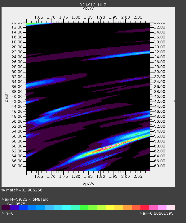
| Estimated Moho Depth: |
59.25 km |
| Estimated Crust Vp/Vs: |
1.96 |
| Assumed Crust Vp: |
6.483 km/s |
| Estimated Crust Vs: |
3.312 km/s |
| Estimated Crust Poisson's Ratio: |
0.32 |
|
| Radial Match: |
81.905266 % |
| Radial Bump: |
383 |
| Transverse Match: |
48.767616 % |
| Transverse Bump: |
400 |
| SOD ConfigId: |
20465011 |
| Insert Time: |
2020-01-21 08:42:01.601 +0000 |
| GWidth: |
2.5 |
| Max Bumps: |
400 |
| Tol: |
0.001 |
|

Signal To Noise
| Channel | StoN | STA | LTA |
| O2:KS13: :HHZ:20200107T08:30:30.814986Z | 4.293068 | 2.3430982E-6 | 5.4578646E-7 |
| O2:KS13: :HHN:20200107T08:30:30.814986Z | 2.2819538 | 1.7835246E-6 | 7.8157785E-7 |
| O2:KS13: :HHE:20200107T08:30:30.814986Z | 1.7859205 | 1.5062345E-6 | 8.4339393E-7 |
| Arrivals |
| Ps | 9.4 SECOND |
| PpPs | 25 SECOND |
| PsPs/PpSs | 35 SECOND |


