You are here: Home > Network List > O2 - Oklahoma Consolidated Temporary Seismic Networks Stations List
> Station PW13 Pawnee, Oklahoma, USA > Earthquake Result Viewer
PW13 Pawnee, Oklahoma, USA - Earthquake Result Viewer
| Earthquake location: |
Puerto Rico Region |
| Earthquake latitude/longitude: |
17.9/-66.8 |
| Earthquake time(UTC): |
2020/01/07 (007) 08:24:26 GMT |
| Earthquake Depth: |
10 km |
| Earthquake Magnitude: |
6.4 mww |
| Earthquake Catalog/Contributor: |
NEIC PDE/us |
|
| Network: |
O2 Oklahoma Consolidated Temporary Seismic Networks |
| Station: |
PW13 Pawnee, Oklahoma, USA |
| Lat/Lon: |
36.33 N/96.82 W |
| Elevation: |
290 m |
|
| Distance: |
32.2 deg |
| Az: |
310.734 deg |
| Baz: |
116.694 deg |
| Ray Param: |
0.07876767 |
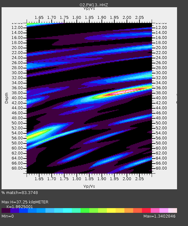
| Estimated Moho Depth: |
37.25 km |
| Estimated Crust Vp/Vs: |
1.99 |
| Assumed Crust Vp: |
6.483 km/s |
| Estimated Crust Vs: |
3.254 km/s |
| Estimated Crust Poisson's Ratio: |
0.33 |
|
| Radial Match: |
83.3748 % |
| Radial Bump: |
353 |
| Transverse Match: |
65.01407 % |
| Transverse Bump: |
400 |
| SOD ConfigId: |
20465011 |
| Insert Time: |
2020-01-21 08:42:15.153 +0000 |
| GWidth: |
2.5 |
| Max Bumps: |
400 |
| Tol: |
0.001 |
|

Signal To Noise
| Channel | StoN | STA | LTA |
| O2:PW13: :HHZ:20200107T08:30:23.990004Z | 5.303403 | 2.4718279E-6 | 4.6608335E-7 |
| O2:PW13: :HHN:20200107T08:30:23.990004Z | 1.2863394 | 6.3278037E-7 | 4.9192334E-7 |
| O2:PW13: :HHE:20200107T08:30:23.990004Z | 2.5712214 | 1.3746385E-6 | 5.3462475E-7 |
| Arrivals |
| Ps | 6.1 SECOND |
| PpPs | 16 SECOND |
| PsPs/PpSs | 22 SECOND |


