You are here: Home > Network List > WI - West Indies IPGP Network Stations List
> Station BIM Morne Bigot, Anses d'Arlets, Martinique > Earthquake Result Viewer
BIM Morne Bigot, Anses d'Arlets, Martinique - Earthquake Result Viewer

| Earthquake location: |
Chile-Argentina Border Region |
| Earthquake latitude/longitude: |
-23.2/-67.7 |
| Earthquake time(UTC): |
2017/04/15 (105) 08:19:41 GMT |
| Earthquake Depth: |
135 km |
| Earthquake Magnitude: |
6.2 Mww |
| Earthquake Catalog/Contributor: |
NEIC PDE/us |
|
| Network: |
WI West Indies IPGP Network |
| Station: |
BIM Morne Bigot, Anses d'Arlets, Martinique |
| Lat/Lon: |
14.52 N/61.07 W |
| Elevation: |
391 m |
|
| Distance: |
38.1 deg |
| Az: |
10.379 deg |
| Baz: |
189.852 deg |
| Ray Param: |
0.075293705 |
| Estimated Moho Depth: |
67.75 km |
| Estimated Crust Vp/Vs: |
1.99 |
| Assumed Crust Vp: |
5.88 km/s |
| Estimated Crust Vs: |
2.955 km/s |
| Estimated Crust Poisson's Ratio: |
0.33 |
|
| Radial Match: |
81.62636 % |
| Radial Bump: |
400 |
| Transverse Match: |
75.10003 % |
| Transverse Bump: |
400 |
| SOD ConfigId: |
2028011 |
| Insert Time: |
2017-04-29 08:37:45.731 +0000 |
| GWidth: |
2.5 |
| Max Bumps: |
400 |
| Tol: |
0.001 |
|
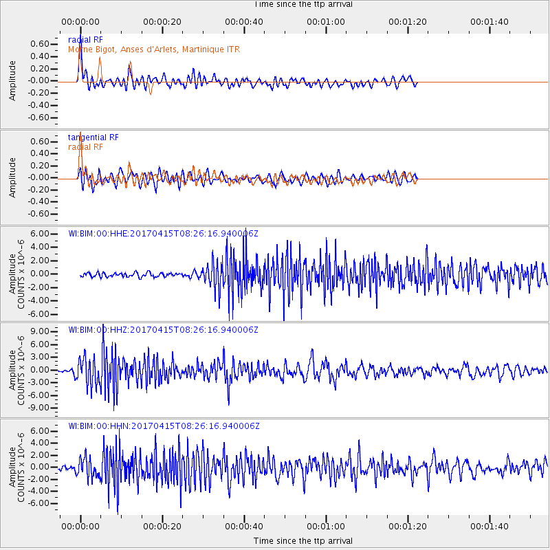
Signal To Noise
| Channel | StoN | STA | LTA |
| WI:BIM:00:HHZ:20170415T08:26:16.940006Z | 13.481716 | 3.048452E-6 | 2.261175E-7 |
| WI:BIM:00:HHN:20170415T08:26:16.940006Z | 4.6949067 | 1.5593353E-6 | 3.3213337E-7 |
| WI:BIM:00:HHE:20170415T08:26:16.940006Z | 6.168762 | 1.7979912E-6 | 2.914671E-7 |
| Arrivals |
| Ps | 12 SECOND |
| PpPs | 33 SECOND |
| PsPs/PpSs | 45 SECOND |


