You are here: Home > Network List > WI - West Indies IPGP Network Stations List
> Station MPOM Morne Pois, Sainte-Anne, Martinique > Earthquake Result Viewer
MPOM Morne Pois, Sainte-Anne, Martinique - Earthquake Result Viewer
| Earthquake location: |
Chile-Argentina Border Region |
| Earthquake latitude/longitude: |
-23.2/-67.7 |
| Earthquake time(UTC): |
2017/04/15 (105) 08:19:41 GMT |
| Earthquake Depth: |
135 km |
| Earthquake Magnitude: |
6.2 Mww |
| Earthquake Catalog/Contributor: |
NEIC PDE/us |
|
| Network: |
WI West Indies IPGP Network |
| Station: |
MPOM Morne Pois, Sainte-Anne, Martinique |
| Lat/Lon: |
14.45 N/60.86 W |
| Elevation: |
50 m |
|
| Distance: |
38.0 deg |
| Az: |
10.719 deg |
| Baz: |
190.172 deg |
| Ray Param: |
0.07531351 |
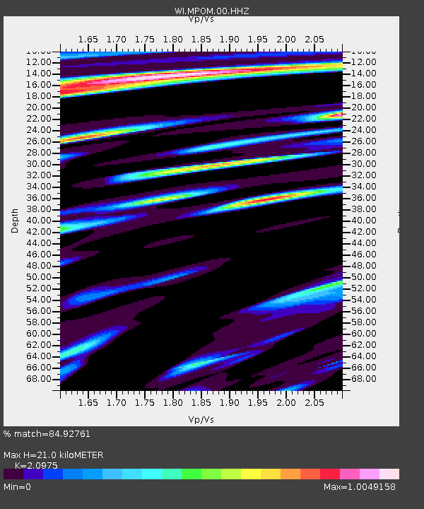
| Estimated Moho Depth: |
21.0 km |
| Estimated Crust Vp/Vs: |
2.10 |
| Assumed Crust Vp: |
5.88 km/s |
| Estimated Crust Vs: |
2.804 km/s |
| Estimated Crust Poisson's Ratio: |
0.35 |
|
| Radial Match: |
84.92761 % |
| Radial Bump: |
400 |
| Transverse Match: |
74.9547 % |
| Transverse Bump: |
400 |
| SOD ConfigId: |
2028011 |
| Insert Time: |
2017-04-29 08:38:05.178 +0000 |
| GWidth: |
2.5 |
| Max Bumps: |
400 |
| Tol: |
0.001 |
|

Signal To Noise
| Channel | StoN | STA | LTA |
| WI:MPOM:00:HHZ:20170415T08:26:16.649998Z | 8.752142 | 2.3001526E-6 | 2.6281026E-7 |
| WI:MPOM:00:HHN:20170415T08:26:16.649998Z | 5.4729724 | 1.0841653E-6 | 1.9809441E-7 |
| WI:MPOM:00:HHE:20170415T08:26:16.649998Z | 1.7382482 | 4.8404445E-7 | 2.784668E-7 |
| Arrivals |
| Ps | 4.1 SECOND |
| PpPs | 11 SECOND |
| PsPs/PpSs | 15 SECOND |


