You are here: Home > Network List > TA - USArray Transportable Network (new EarthScope stations) Stations List
> Station C18K Utukok River, AK, USA > Earthquake Result Viewer
C18K Utukok River, AK, USA - Earthquake Result Viewer
| Earthquake location: |
Puerto Rico Region |
| Earthquake latitude/longitude: |
17.9/-66.8 |
| Earthquake time(UTC): |
2020/01/07 (007) 08:24:26 GMT |
| Earthquake Depth: |
10 km |
| Earthquake Magnitude: |
6.4 mww |
| Earthquake Catalog/Contributor: |
NEIC PDE/us |
|
| Network: |
TA USArray Transportable Network (new EarthScope stations) |
| Station: |
C18K Utukok River, AK, USA |
| Lat/Lon: |
68.65 N/161.19 W |
| Elevation: |
845 m |
|
| Distance: |
75.1 deg |
| Az: |
337.795 deg |
| Baz: |
79.283 deg |
| Ray Param: |
0.051925454 |
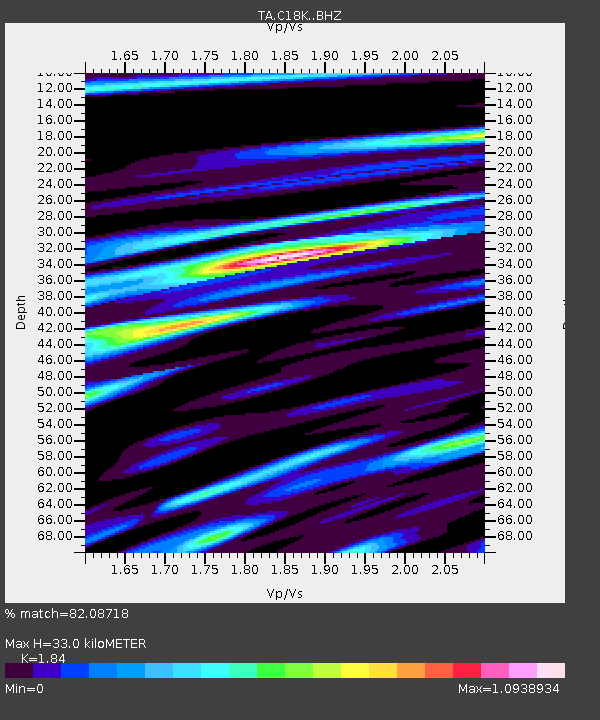
| Estimated Moho Depth: |
33.0 km |
| Estimated Crust Vp/Vs: |
1.84 |
| Assumed Crust Vp: |
5.906 km/s |
| Estimated Crust Vs: |
3.21 km/s |
| Estimated Crust Poisson's Ratio: |
0.29 |
|
| Radial Match: |
82.08718 % |
| Radial Bump: |
400 |
| Transverse Match: |
75.34984 % |
| Transverse Bump: |
400 |
| SOD ConfigId: |
20465011 |
| Insert Time: |
2020-01-21 08:45:19.671 +0000 |
| GWidth: |
2.5 |
| Max Bumps: |
400 |
| Tol: |
0.001 |
|

Signal To Noise
| Channel | StoN | STA | LTA |
| TA:C18K: :BHZ:20200107T08:35:37.049971Z | 5.6927094 | 1.397008E-6 | 2.45403E-7 |
| TA:C18K: :BHN:20200107T08:35:37.049971Z | 1.9252281 | 3.851656E-7 | 2.0006232E-7 |
| TA:C18K: :BHE:20200107T08:35:37.049971Z | 3.3167138 | 5.1498927E-7 | 1.5527094E-7 |
| Arrivals |
| Ps | 4.8 SECOND |
| PpPs | 15 SECOND |
| PsPs/PpSs | 20 SECOND |


