You are here: Home > Network List > TA - USArray Transportable Network (new EarthScope stations) Stations List
> Station F24K Squaw Lake, AK, USA > Earthquake Result Viewer
F24K Squaw Lake, AK, USA - Earthquake Result Viewer
| Earthquake location: |
Puerto Rico Region |
| Earthquake latitude/longitude: |
17.9/-66.8 |
| Earthquake time(UTC): |
2020/01/07 (007) 08:24:26 GMT |
| Earthquake Depth: |
10 km |
| Earthquake Magnitude: |
6.4 mww |
| Earthquake Catalog/Contributor: |
NEIC PDE/us |
|
| Network: |
TA USArray Transportable Network (new EarthScope stations) |
| Station: |
F24K Squaw Lake, AK, USA |
| Lat/Lon: |
67.52 N/147.89 W |
| Elevation: |
736 m |
|
| Distance: |
70.2 deg |
| Az: |
336.181 deg |
| Baz: |
91.143 deg |
| Ray Param: |
0.05517012 |
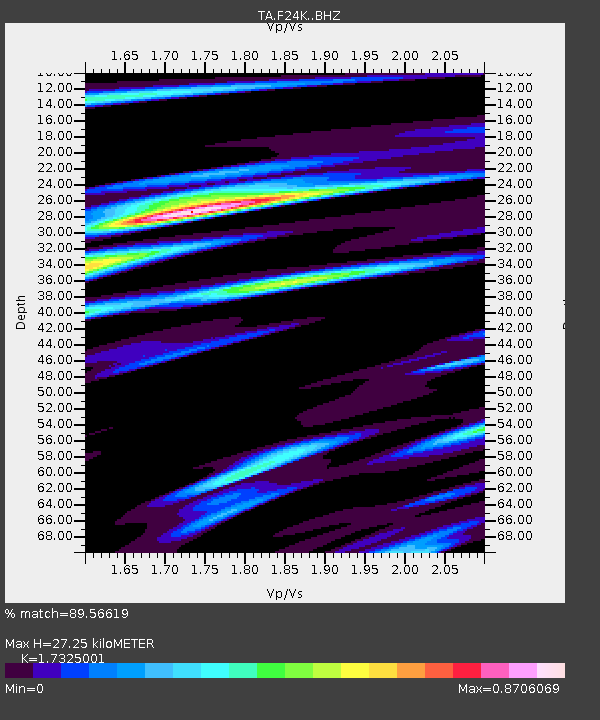
| Estimated Moho Depth: |
27.25 km |
| Estimated Crust Vp/Vs: |
1.73 |
| Assumed Crust Vp: |
6.522 km/s |
| Estimated Crust Vs: |
3.764 km/s |
| Estimated Crust Poisson's Ratio: |
0.25 |
|
| Radial Match: |
89.56619 % |
| Radial Bump: |
400 |
| Transverse Match: |
82.8506 % |
| Transverse Bump: |
400 |
| SOD ConfigId: |
20465011 |
| Insert Time: |
2020-01-21 08:46:04.904 +0000 |
| GWidth: |
2.5 |
| Max Bumps: |
400 |
| Tol: |
0.001 |
|
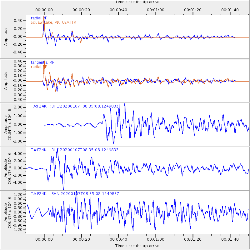
Signal To Noise
| Channel | StoN | STA | LTA |
| TA:F24K: :BHZ:20200107T08:35:08.124983Z | 10.422739 | 1.8460205E-6 | 1.7711471E-7 |
| TA:F24K: :BHN:20200107T08:35:08.124983Z | 0.68914497 | 1.8059771E-7 | 2.6206055E-7 |
| TA:F24K: :BHE:20200107T08:35:08.124983Z | 7.267981 | 8.1494505E-7 | 1.1212813E-7 |
| Arrivals |
| Ps | 3.2 SECOND |
| PpPs | 11 SECOND |
| PsPs/PpSs | 14 SECOND |


