You are here: Home > Network List > TA - USArray Transportable Network (new EarthScope stations) Stations List
> Station G23K Bananza Creek, AK, USA > Earthquake Result Viewer
G23K Bananza Creek, AK, USA - Earthquake Result Viewer
| Earthquake location: |
Puerto Rico Region |
| Earthquake latitude/longitude: |
17.9/-66.8 |
| Earthquake time(UTC): |
2020/01/07 (007) 08:24:26 GMT |
| Earthquake Depth: |
10 km |
| Earthquake Magnitude: |
6.4 mww |
| Earthquake Catalog/Contributor: |
NEIC PDE/us |
|
| Network: |
TA USArray Transportable Network (new EarthScope stations) |
| Station: |
G23K Bananza Creek, AK, USA |
| Lat/Lon: |
66.71 N/150.02 W |
| Elevation: |
746 m |
|
| Distance: |
71.0 deg |
| Az: |
335.321 deg |
| Baz: |
88.891 deg |
| Ray Param: |
0.05460356 |
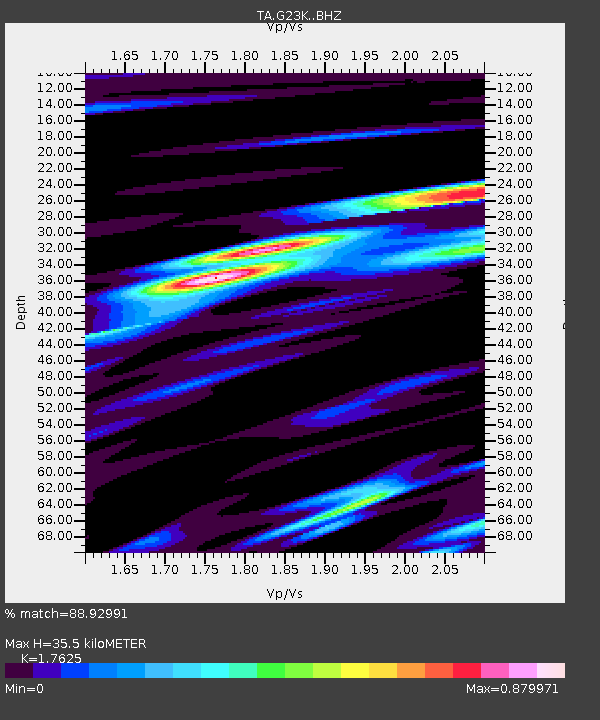
| Estimated Moho Depth: |
35.5 km |
| Estimated Crust Vp/Vs: |
1.76 |
| Assumed Crust Vp: |
6.577 km/s |
| Estimated Crust Vs: |
3.731 km/s |
| Estimated Crust Poisson's Ratio: |
0.26 |
|
| Radial Match: |
88.92991 % |
| Radial Bump: |
400 |
| Transverse Match: |
83.25337 % |
| Transverse Bump: |
400 |
| SOD ConfigId: |
20465011 |
| Insert Time: |
2020-01-21 08:46:23.099 +0000 |
| GWidth: |
2.5 |
| Max Bumps: |
400 |
| Tol: |
0.001 |
|
Signal To Noise
| Channel | StoN | STA | LTA |
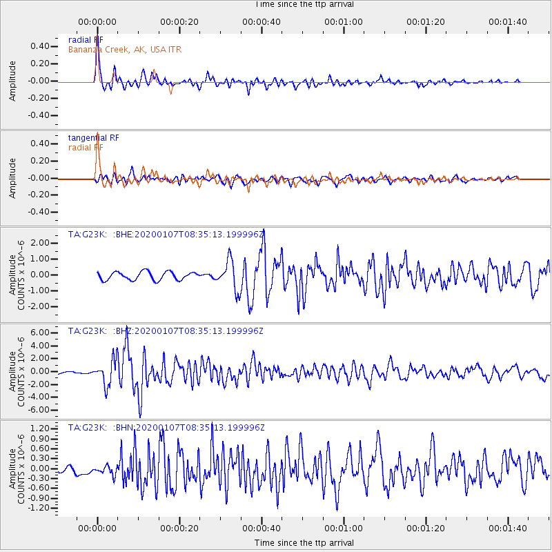
| TA:G23K: :BHZ:20200107T08:35:13.199996Z | 13.236539 | 2.022554E-6 | 1.5280082E-7 |
| TA:G23K: :BHN:20200107T08:35:13.199996Z | 1.0248184 | 1.3591567E-7 | 1.3262415E-7 |
| TA:G23K: :BHE:20200107T08:35:13.199996Z | 3.762375 | 9.571775E-7 | 2.5440778E-7 |
| Arrivals |
| Ps | 4.3 SECOND |
| PpPs | 14 SECOND |
| PsPs/PpSs | 19 SECOND |


