You are here: Home > Network List > TX - Texas Seismological Network Stations List
> Station FW07 Weatherford > Earthquake Result Viewer
FW07 Weatherford - Earthquake Result Viewer
| Earthquake location: |
Chile-Argentina Border Region |
| Earthquake latitude/longitude: |
-23.2/-67.7 |
| Earthquake time(UTC): |
2017/04/15 (105) 08:19:41 GMT |
| Earthquake Depth: |
135 km |
| Earthquake Magnitude: |
6.2 Mww |
| Earthquake Catalog/Contributor: |
NEIC PDE/us |
|
| Network: |
TX Texas Seismological Network |
| Station: |
FW07 Weatherford |
| Lat/Lon: |
32.70 N/97.79 W |
| Elevation: |
311 m |
|
| Distance: |
62.6 deg |
| Az: |
331.534 deg |
| Baz: |
148.667 deg |
| Ray Param: |
0.059714675 |
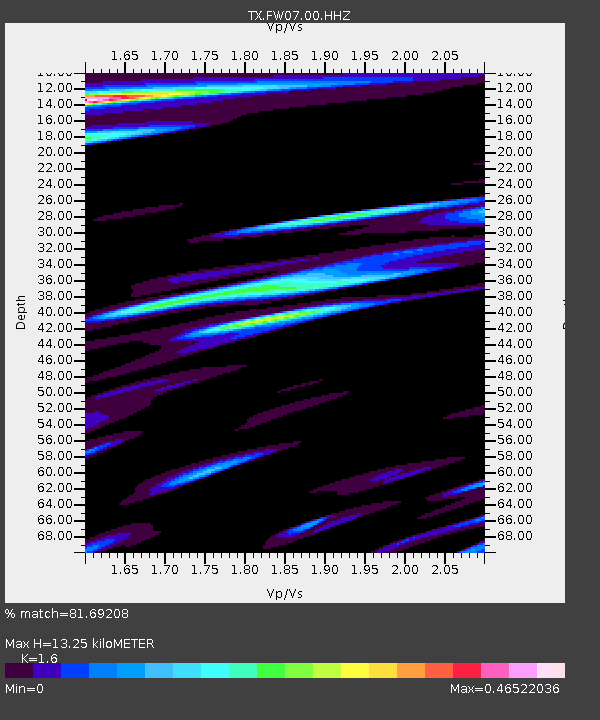
| Estimated Moho Depth: |
13.25 km |
| Estimated Crust Vp/Vs: |
1.60 |
| Assumed Crust Vp: |
6.38 km/s |
| Estimated Crust Vs: |
3.988 km/s |
| Estimated Crust Poisson's Ratio: |
0.18 |
|
| Radial Match: |
81.69208 % |
| Radial Bump: |
400 |
| Transverse Match: |
70.80932 % |
| Transverse Bump: |
400 |
| SOD ConfigId: |
2028011 |
| Insert Time: |
2017-04-29 08:39:33.488 +0000 |
| GWidth: |
2.5 |
| Max Bumps: |
400 |
| Tol: |
0.001 |
|

Signal To Noise
| Channel | StoN | STA | LTA |
| TX:FW07:00:HHZ:20170415T08:29:21.07999Z | 15.941334 | 1.7999541E-6 | 1.1291114E-7 |
| TX:FW07:00:HH1:20170415T08:29:21.07999Z | 5.9918933 | 7.099076E-7 | 1.1847802E-7 |
| TX:FW07:00:HH2:20170415T08:29:21.07999Z | 4.558498 | 4.666745E-7 | 1.0237462E-7 |
| Arrivals |
| Ps | 1.3 SECOND |
| PpPs | 5.1 SECOND |
| PsPs/PpSs | 6.5 SECOND |


