You are here: Home > Network List > TX - Texas Seismological Network Stations List
> Station FW14 Alvarado > Earthquake Result Viewer
FW14 Alvarado - Earthquake Result Viewer
| Earthquake location: |
Chile-Argentina Border Region |
| Earthquake latitude/longitude: |
-23.2/-67.7 |
| Earthquake time(UTC): |
2017/04/15 (105) 08:19:41 GMT |
| Earthquake Depth: |
135 km |
| Earthquake Magnitude: |
6.2 Mww |
| Earthquake Catalog/Contributor: |
NEIC PDE/us |
|
| Network: |
TX Texas Seismological Network |
| Station: |
FW14 Alvarado |
| Lat/Lon: |
32.40 N/97.19 W |
| Elevation: |
219 m |
|
| Distance: |
62.1 deg |
| Az: |
331.842 deg |
| Baz: |
149.128 deg |
| Ray Param: |
0.060047343 |
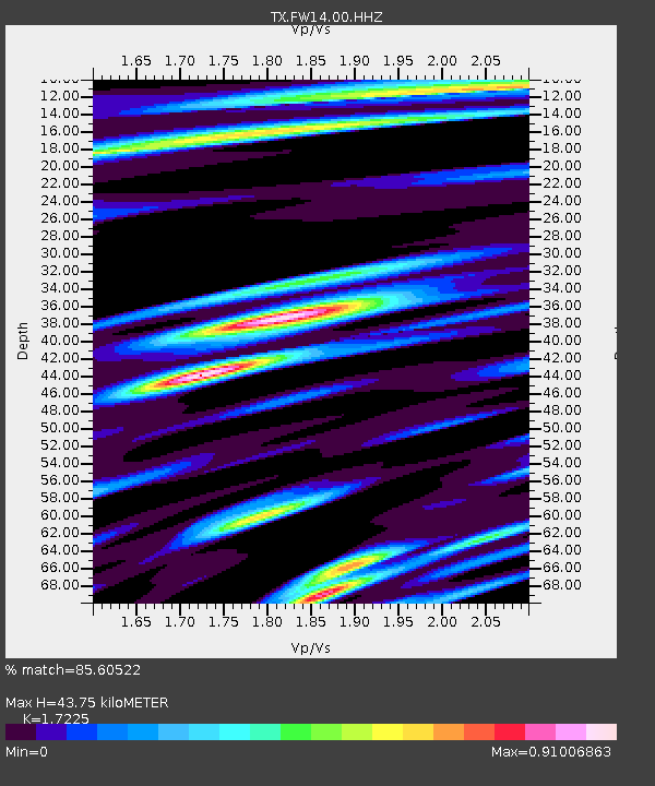
| Estimated Moho Depth: |
43.75 km |
| Estimated Crust Vp/Vs: |
1.72 |
| Assumed Crust Vp: |
6.38 km/s |
| Estimated Crust Vs: |
3.704 km/s |
| Estimated Crust Poisson's Ratio: |
0.25 |
|
| Radial Match: |
85.60522 % |
| Radial Bump: |
400 |
| Transverse Match: |
73.953606 % |
| Transverse Bump: |
400 |
| SOD ConfigId: |
2028011 |
| Insert Time: |
2017-04-29 08:39:38.454 +0000 |
| GWidth: |
2.5 |
| Max Bumps: |
400 |
| Tol: |
0.001 |
|

Signal To Noise
| Channel | StoN | STA | LTA |
| TX:FW14:00:HHZ:20170415T08:29:17.649998Z | 18.79717 | 2.1309188E-6 | 1.1336381E-7 |
| TX:FW14:00:HH1:20170415T08:29:17.649998Z | 7.1255465 | 8.32956E-7 | 1.1689714E-7 |
| TX:FW14:00:HH2:20170415T08:29:17.649998Z | 4.257041 | 4.1574313E-7 | 9.766012E-8 |
| Arrivals |
| Ps | 5.2 SECOND |
| PpPs | 18 SECOND |
| PsPs/PpSs | 23 SECOND |


