You are here: Home > Network List > TX - Texas Seismological Network Stations List
> Station FW15 Z > Earthquake Result Viewer
FW15 Z - Earthquake Result Viewer

| Earthquake location: |
Puerto Rico Region |
| Earthquake latitude/longitude: |
17.9/-66.8 |
| Earthquake time(UTC): |
2020/01/07 (007) 08:24:26 GMT |
| Earthquake Depth: |
10 km |
| Earthquake Magnitude: |
6.4 mww |
| Earthquake Catalog/Contributor: |
NEIC PDE/us |
|
| Network: |
TX Texas Seismological Network |
| Station: |
FW15 Z |
| Lat/Lon: |
32.70 N/97.37 W |
| Elevation: |
192 m |
|
| Distance: |
31.2 deg |
| Az: |
304.081 deg |
| Baz: |
110.719 deg |
| Ray Param: |
0.07917738 |
| Estimated Moho Depth: |
54.0 km |
| Estimated Crust Vp/Vs: |
1.86 |
| Assumed Crust Vp: |
6.38 km/s |
| Estimated Crust Vs: |
3.435 km/s |
| Estimated Crust Poisson's Ratio: |
0.30 |
|
| Radial Match: |
89.785545 % |
| Radial Bump: |
294 |
| Transverse Match: |
68.57377 % |
| Transverse Bump: |
400 |
| SOD ConfigId: |
20465011 |
| Insert Time: |
2020-01-21 08:48:48.813 +0000 |
| GWidth: |
2.5 |
| Max Bumps: |
400 |
| Tol: |
0.001 |
|
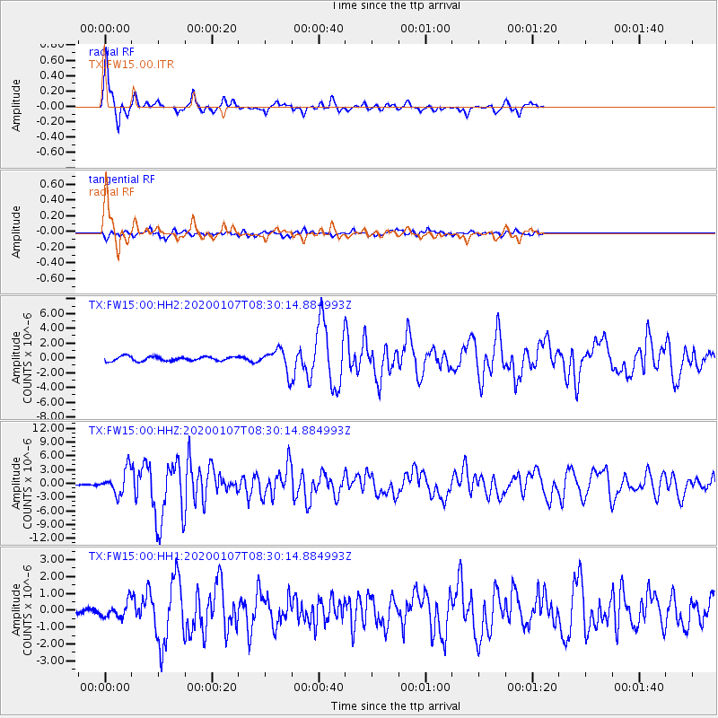
Signal To Noise
| Channel | StoN | STA | LTA |
| TX:FW15:00:HHZ:20200107T08:30:14.884993Z | 16.182611 | 2.6425066E-6 | 1.6329297E-7 |
| TX:FW15:00:HH1:20200107T08:30:14.884993Z | 1.5512868 | 4.5282266E-7 | 2.9190133E-7 |
| TX:FW15:00:HH2:20200107T08:30:14.884993Z | 5.2534556 | 1.5110384E-6 | 2.876275E-7 |
| Arrivals |
| Ps | 7.8 SECOND |
| PpPs | 22 SECOND |
| PsPs/PpSs | 30 SECOND |


