You are here: Home > Network List > TX - Texas Seismological Network Stations List
> Station PB09 Culberson County > Earthquake Result Viewer
PB09 Culberson County - Earthquake Result Viewer
| Earthquake location: |
Puerto Rico Region |
| Earthquake latitude/longitude: |
17.9/-66.8 |
| Earthquake time(UTC): |
2020/01/07 (007) 08:24:26 GMT |
| Earthquake Depth: |
10 km |
| Earthquake Magnitude: |
6.4 mww |
| Earthquake Catalog/Contributor: |
NEIC PDE/us |
|
| Network: |
TX Texas Seismological Network |
| Station: |
PB09 Culberson County |
| Lat/Lon: |
31.77 N/104.30 W |
| Elevation: |
1139 m |
|
| Distance: |
36.5 deg |
| Az: |
299.418 deg |
| Baz: |
103.158 deg |
| Ray Param: |
0.0766679 |
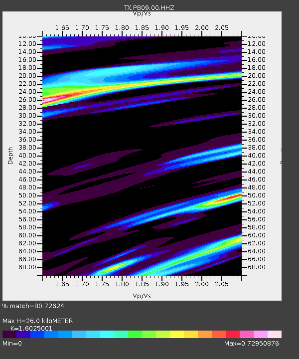
| Estimated Moho Depth: |
26.0 km |
| Estimated Crust Vp/Vs: |
1.60 |
| Assumed Crust Vp: |
6.361 km/s |
| Estimated Crust Vs: |
3.969 km/s |
| Estimated Crust Poisson's Ratio: |
0.18 |
|
| Radial Match: |
80.72624 % |
| Radial Bump: |
336 |
| Transverse Match: |
63.038914 % |
| Transverse Bump: |
400 |
| SOD ConfigId: |
20465011 |
| Insert Time: |
2020-01-21 08:49:14.862 +0000 |
| GWidth: |
2.5 |
| Max Bumps: |
400 |
| Tol: |
0.001 |
|

Signal To Noise
| Channel | StoN | STA | LTA |
| TX:PB09:00:HHZ:20200107T08:31:01.259993Z | 1.7650968 | 1.6154127E-6 | 9.1519775E-7 |
| TX:PB09:00:HHN:20200107T08:31:01.259993Z | 1.2696865 | 5.550036E-7 | 4.3711867E-7 |
| TX:PB09:00:HHE:20200107T08:31:01.259993Z | 1.5344485 | 1.0732438E-6 | 6.994329E-7 |
| Arrivals |
| Ps | 2.7 SECOND |
| PpPs | 9.8 SECOND |
| PsPs/PpSs | 12 SECOND |


