You are here: Home > Network List > MN - MEDNET Project Stations List
> Station KEG Kottamya, Egypt > Earthquake Result Viewer
KEG Kottamya, Egypt - Earthquake Result Viewer
| Earthquake location: |
Sunda Strait, Indonesia |
| Earthquake latitude/longitude: |
-6.6/105.5 |
| Earthquake time(UTC): |
1997/03/17 (076) 08:05:48 GMT |
| Earthquake Depth: |
33 km |
| Earthquake Magnitude: |
5.8 MB, 6.2 MS, 6.4 UNKNOWN, 6.3 MW |
| Earthquake Catalog/Contributor: |
WHDF/NEIC |
|
| Network: |
MN MEDNET Project |
| Station: |
KEG Kottamya, Egypt |
| Lat/Lon: |
29.93 N/31.83 E |
| Elevation: |
460 m |
|
| Distance: |
79.3 deg |
| Az: |
302.021 deg |
| Baz: |
104.008 deg |
| Ray Param: |
0.04900203 |
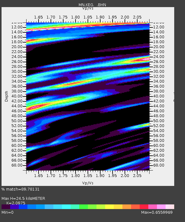
| Estimated Moho Depth: |
24.5 km |
| Estimated Crust Vp/Vs: |
2.10 |
| Assumed Crust Vp: |
6.312 km/s |
| Estimated Crust Vs: |
3.01 km/s |
| Estimated Crust Poisson's Ratio: |
0.35 |
|
| Radial Match: |
89.78131 % |
| Radial Bump: |
400 |
| Transverse Match: |
85.509674 % |
| Transverse Bump: |
400 |
| SOD ConfigId: |
4480 |
| Insert Time: |
2010-03-08 17:11:37.220 +0000 |
| GWidth: |
2.5 |
| Max Bumps: |
400 |
| Tol: |
0.001 |
|
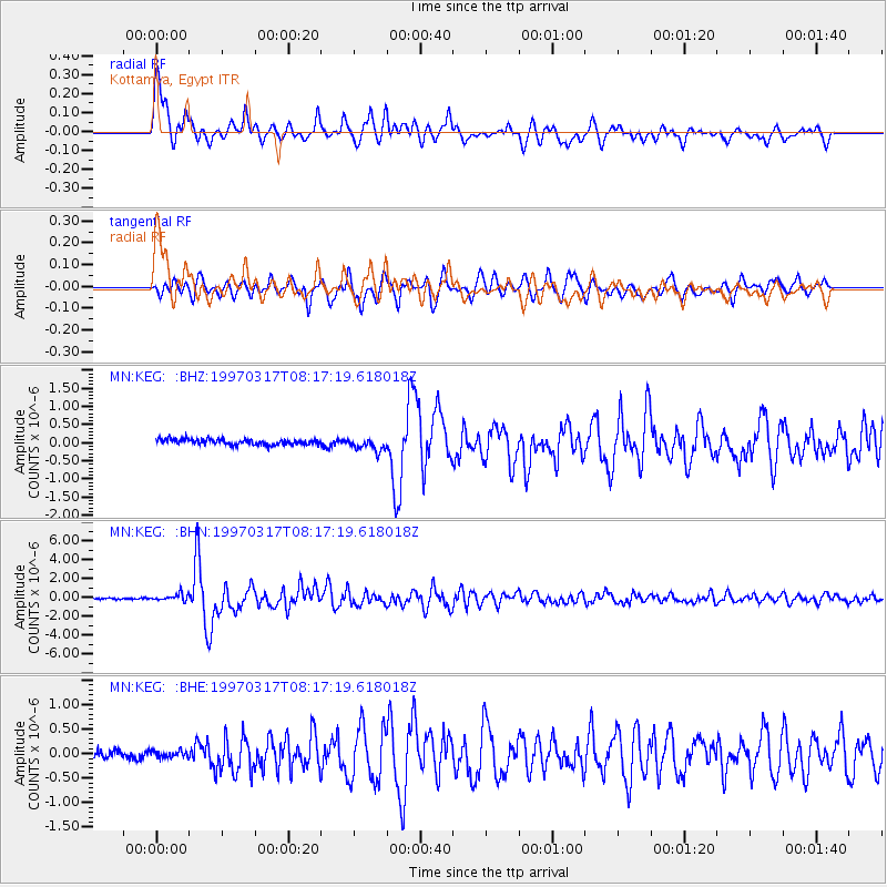
Signal To Noise
| Channel | StoN | STA | LTA |
| MN:KEG: :BHN:19970317T08:17:19.618018Z | 4.9024105 | 3.8069194E-7 | 7.765403E-8 |
| MN:KEG: :BHE:19970317T08:17:19.618018Z | 0.90578413 | 6.3640236E-8 | 7.025983E-8 |
| MN:KEG: :BHZ:19970317T08:17:19.618018Z | 2.3454905 | 1.7821743E-7 | 7.598301E-8 |
| Arrivals |
| Ps | 4.4 SECOND |
| PpPs | 12 SECOND |
| PsPs/PpSs | 16 SECOND |


