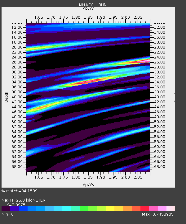
KEG Kottamya, Egypt - Earthquake Result Viewer
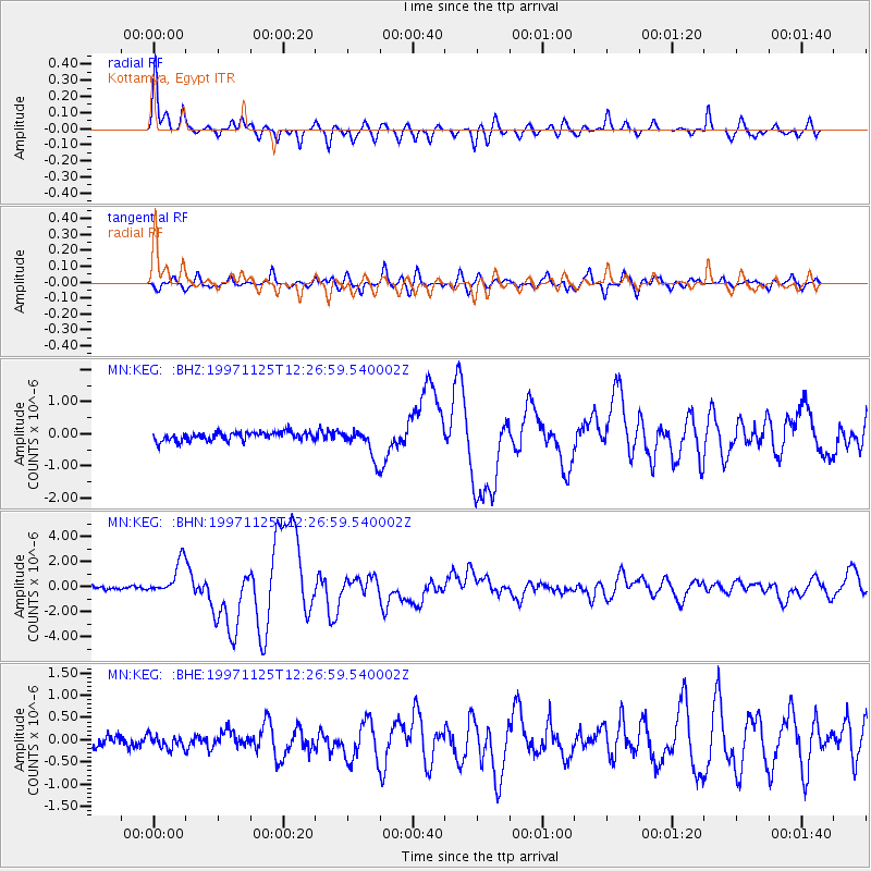
Earthquake location: Minahassa Peninsula, Sulawesi
Earthquake latitude/longitude: 1.2/122.5
Earthquake time(UTC): 1997/11/25 (329) 12:14:33 GMT
Earthquake Depth: 24 km
Earthquake Magnitude: 6.1 MB, 6.8 MS, 7.1 UNKNOWN, 6.7 ME
Earthquake Catalog/Contributor: WHDF/NEIC
Network: MN MEDNET Project
Station: KEG Kottamya, Egypt
Lat/Lon: 29.93 N/31.83 E
Elevation: 460 m
Distance: 90.0 deg
Az: 299.769 deg
Baz: 88.579 deg
Ray Param: 0.041702166
Estimated Moho Depth: 25.0 km
Estimated Crust Vp/Vs: 2.10
Assumed Crust Vp: 6.312 km/s
Estimated Crust Vs: 3.01 km/s
Estimated Crust Poisson's Ratio: 0.35
Radial Match: 94.1589 %
Radial Bump: 400
Transverse Match: 89.79636 %
Transverse Bump: 400
SOD ConfigId: 4480
Insert Time: 2010-03-08 17:11:55.213 +0000
GWidth: 2.5
Max Bumps: 400
Tol: 0.001

Signal To Noise

ChannelStoNSTALTA
MN:KEG: :BHN:19971125T12:26:59.540002Z12.8595721.3607292E-61.0581451E-7
MN:KEG: :BHE:19971125T12:26:59.540002Z1.24594251.4236524E-71.14263095E-7
MN:KEG: :BHZ:19971125T12:26:59.540002Z3.53898724.6128363E-71.3034341E-7
Arrivals
Ps4.4 SECOND
PpPs12 SECOND
PsPs/PpSs16 SECOND