You are here: Home > Network List > IU - Global Seismograph Network (GSN - IRIS/USGS) Stations List
> Station PMG Port Moresby, New Guinea > Earthquake Result Viewer
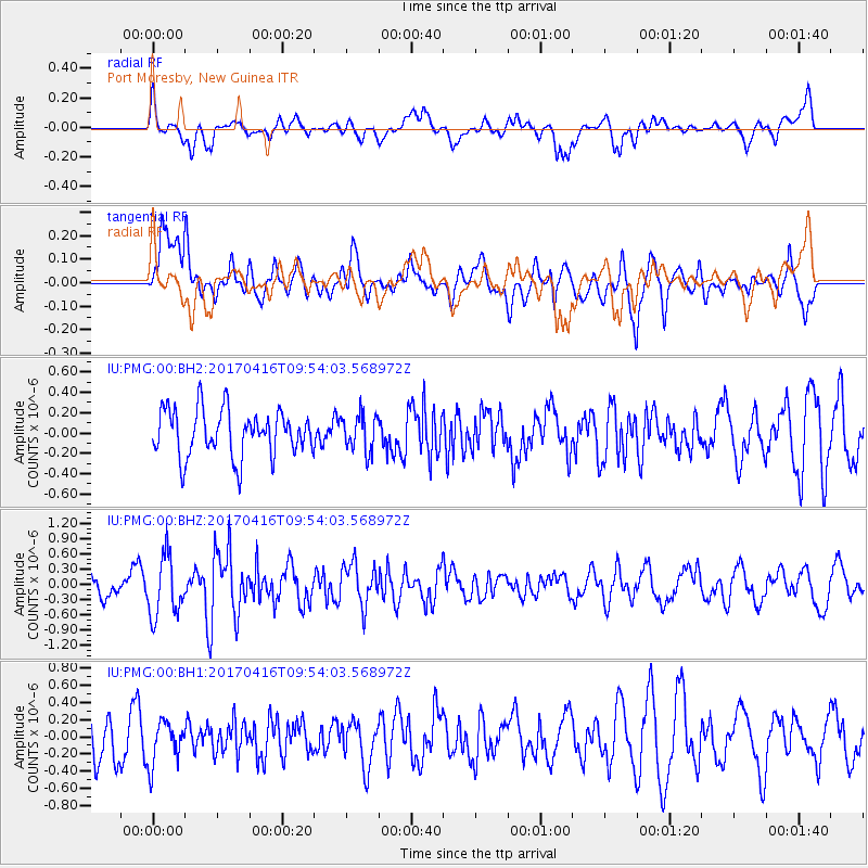
PMG Port Moresby, New Guinea - Earthquake Result Viewer
*The percent match for this event was below the threshold and hence no stack was calculated.
| Earthquake location: |
South Indian Ocean |
| Earthquake latitude/longitude: |
-7.3/83.2 |
| Earthquake time(UTC): |
2017/04/16 (106) 09:44:06 GMT |
| Earthquake Depth: |
10 km |
| Earthquake Magnitude: |
5.7 mb |
| Earthquake Catalog/Contributor: |
NEIC PDE/us |
|
| Network: |
IU Global Seismograph Network (GSN - IRIS/USGS) |
| Station: |
PMG Port Moresby, New Guinea |
| Lat/Lon: |
9.40 S/147.16 E |
| Elevation: |
90 m |
|
| Distance: |
63.3 deg |
| Az: |
96.823 deg |
| Baz: |
266.495 deg |
| Ray Param: |
$rayparam |
*The percent match for this event was below the threshold and hence was not used in the summary stack. |
|
| Radial Match: |
54.302284 % |
| Radial Bump: |
400 |
| Transverse Match: |
67.50032 % |
| Transverse Bump: |
400 |
| SOD ConfigId: |
2028011 |
| Insert Time: |
2017-04-30 09:46:50.004 +0000 |
| GWidth: |
2.5 |
| Max Bumps: |
400 |
| Tol: |
0.001 |
|
Signal To Noise
| Channel | StoN | STA | LTA |
| IU:PMG:00:BHZ:20170416T09:54:03.568972Z | 2.4458408 | 5.9129434E-7 | 2.4175503E-7 |
| IU:PMG:00:BH1:20170416T09:54:03.568972Z | 0.86385113 | 2.475504E-7 | 2.8656603E-7 |
| IU:PMG:00:BH2:20170416T09:54:03.568972Z | 0.7945964 | 1.803689E-7 | 2.2699437E-7 |
| Arrivals |
| Ps | |
| PpPs | |
| PsPs/PpSs | |


