You are here: Home > Network List > MN - MEDNET Project Stations List
> Station KEG Kottamya, Egypt > Earthquake Result Viewer
KEG Kottamya, Egypt - Earthquake Result Viewer
| Earthquake location: |
Ryukyu Islands, Japan |
| Earthquake latitude/longitude: |
27.1/127.4 |
| Earthquake time(UTC): |
1991/04/14 (104) 08:08:58 GMT |
| Earthquake Depth: |
105 km |
| Earthquake Magnitude: |
6.2 MB |
| Earthquake Catalog/Contributor: |
WHDF/NEIC |
|
| Network: |
MN MEDNET Project |
| Station: |
KEG Kottamya, Egypt |
| Lat/Lon: |
29.93 N/31.83 E |
| Elevation: |
460 m |
|
| Distance: |
81.4 deg |
| Az: |
299.086 deg |
| Baz: |
63.792 deg |
| Ray Param: |
0.047396652 |
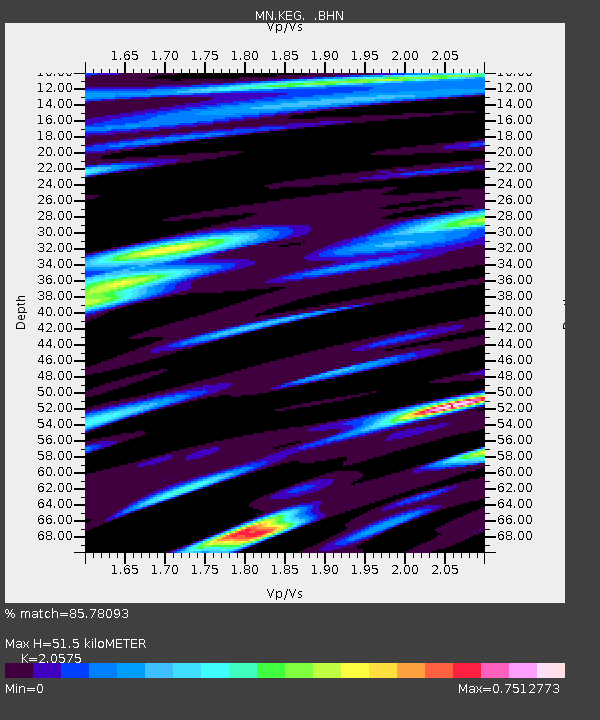
| Estimated Moho Depth: |
51.5 km |
| Estimated Crust Vp/Vs: |
2.06 |
| Assumed Crust Vp: |
6.312 km/s |
| Estimated Crust Vs: |
3.068 km/s |
| Estimated Crust Poisson's Ratio: |
0.35 |
|
| Radial Match: |
85.78093 % |
| Radial Bump: |
400 |
| Transverse Match: |
82.300964 % |
| Transverse Bump: |
400 |
| SOD ConfigId: |
16938 |
| Insert Time: |
2010-03-08 17:12:16.669 +0000 |
| GWidth: |
2.5 |
| Max Bumps: |
400 |
| Tol: |
0.001 |
|
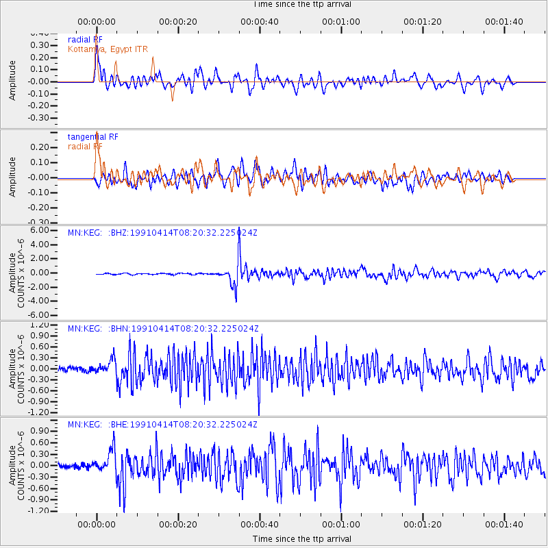
Signal To Noise
| Channel | StoN | STA | LTA |
| MN:KEG: :BHN:19910414T08:20:32.225024Z | 3.0725775 | 2.0598446E-7 | 6.703963E-8 |
| MN:KEG: :BHE:19910414T08:20:32.225024Z | 4.854354 | 3.163619E-7 | 6.517075E-8 |
| MN:KEG: :BHZ:19910414T08:20:32.225024Z | 17.729324 | 1.4313098E-6 | 8.0731205E-8 |
| Arrivals |
| Ps | 8.8 SECOND |
| PpPs | 24 SECOND |
| PsPs/PpSs | 33 SECOND |


