You are here: Home > Network List > MN - MEDNET Project Stations List
> Station KEG Kottamya, Egypt > Earthquake Result Viewer
KEG Kottamya, Egypt - Earthquake Result Viewer
| Earthquake location: |
Central Alaska |
| Earthquake latitude/longitude: |
62.5/-151.5 |
| Earthquake time(UTC): |
1991/05/01 (121) 07:18:42 GMT |
| Earthquake Depth: |
116 km |
| Earthquake Magnitude: |
6.1 MB, 6.4 UNKNOWN |
| Earthquake Catalog/Contributor: |
WHDF/NEIC |
|
| Network: |
MN MEDNET Project |
| Station: |
KEG Kottamya, Egypt |
| Lat/Lon: |
29.93 N/31.83 E |
| Elevation: |
460 m |
|
| Distance: |
87.8 deg |
| Az: |
357.094 deg |
| Baz: |
1.551 deg |
| Ray Param: |
0.042794235 |
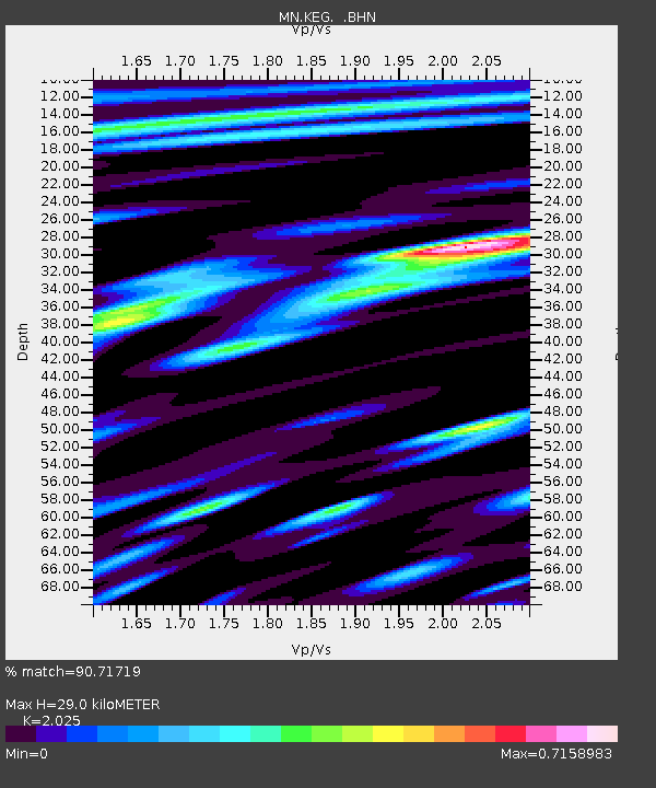
| Estimated Moho Depth: |
29.0 km |
| Estimated Crust Vp/Vs: |
2.03 |
| Assumed Crust Vp: |
6.312 km/s |
| Estimated Crust Vs: |
3.117 km/s |
| Estimated Crust Poisson's Ratio: |
0.34 |
|
| Radial Match: |
90.71719 % |
| Radial Bump: |
400 |
| Transverse Match: |
82.91578 % |
| Transverse Bump: |
400 |
| SOD ConfigId: |
16938 |
| Insert Time: |
2010-03-08 17:12:19.072 +0000 |
| GWidth: |
2.5 |
| Max Bumps: |
400 |
| Tol: |
0.001 |
|
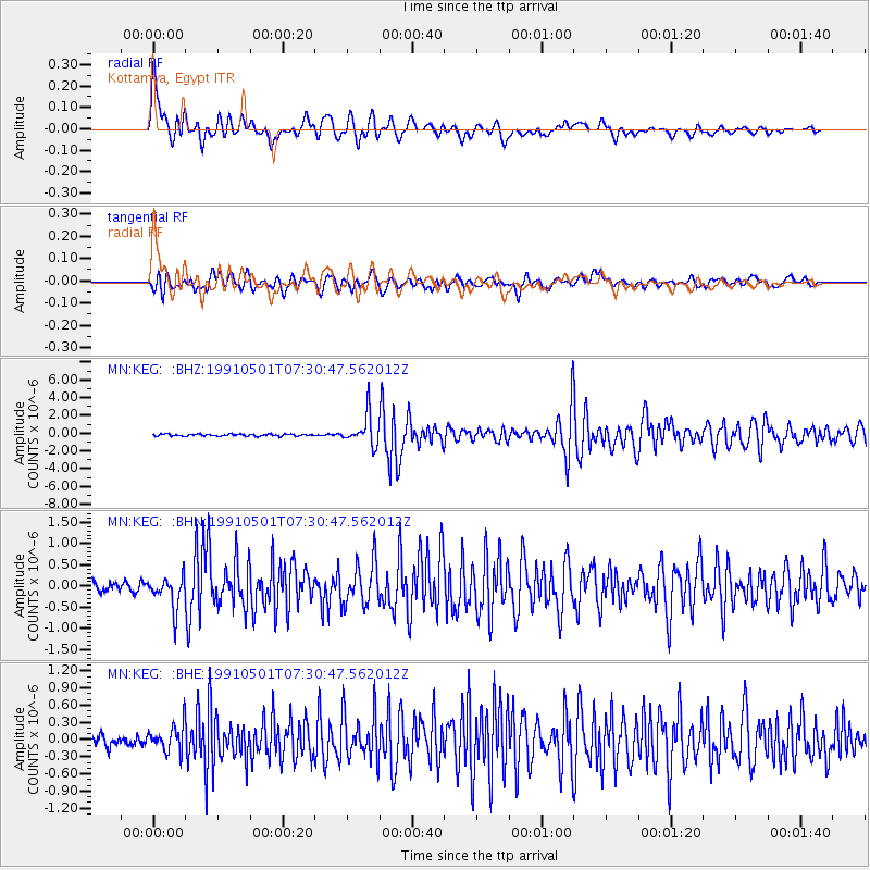
Signal To Noise
| Channel | StoN | STA | LTA |
| MN:KEG: :BHN:19910501T07:30:47.562012Z | 3.2213717 | 3.695611E-7 | 1.1472166E-7 |
| MN:KEG: :BHE:19910501T07:30:47.562012Z | 2.2836926 | 2.4052576E-7 | 1.0532318E-7 |
| MN:KEG: :BHZ:19910501T07:30:47.562012Z | 15.084139 | 1.6914362E-6 | 1.1213343E-7 |
| Arrivals |
| Ps | 4.8 SECOND |
| PpPs | 14 SECOND |
| PsPs/PpSs | 18 SECOND |


