You are here: Home > Network List > MN - MEDNET Project Stations List
> Station KEG Kottamya, Egypt > Earthquake Result Viewer
KEG Kottamya, Egypt - Earthquake Result Viewer
| Earthquake location: |
Bonin Islands, Japan Region |
| Earthquake latitude/longitude: |
28.1/139.6 |
| Earthquake time(UTC): |
1991/05/03 (123) 02:14:17 GMT |
| Earthquake Depth: |
459 km |
| Earthquake Magnitude: |
6.0 MB, 6.0 UNKNOWN |
| Earthquake Catalog/Contributor: |
WHDF/NEIC |
|
| Network: |
MN MEDNET Project |
| Station: |
KEG Kottamya, Egypt |
| Lat/Lon: |
29.93 N/31.83 E |
| Elevation: |
460 m |
|
| Distance: |
90.1 deg |
| Az: |
304.227 deg |
| Baz: |
57.323 deg |
| Ray Param: |
0.041565903 |
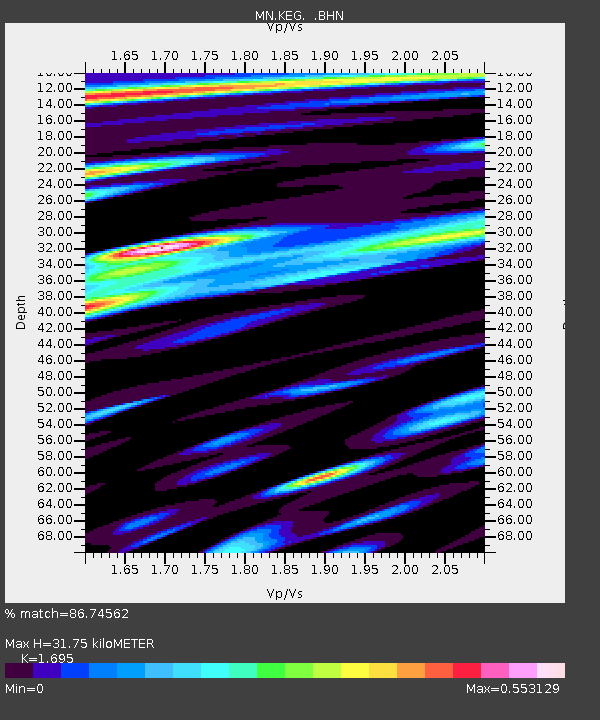
| Estimated Moho Depth: |
31.75 km |
| Estimated Crust Vp/Vs: |
1.70 |
| Assumed Crust Vp: |
6.312 km/s |
| Estimated Crust Vs: |
3.724 km/s |
| Estimated Crust Poisson's Ratio: |
0.23 |
|
| Radial Match: |
86.74562 % |
| Radial Bump: |
400 |
| Transverse Match: |
83.65349 % |
| Transverse Bump: |
400 |
| SOD ConfigId: |
16938 |
| Insert Time: |
2010-03-08 17:12:20.408 +0000 |
| GWidth: |
2.5 |
| Max Bumps: |
400 |
| Tol: |
0.001 |
|
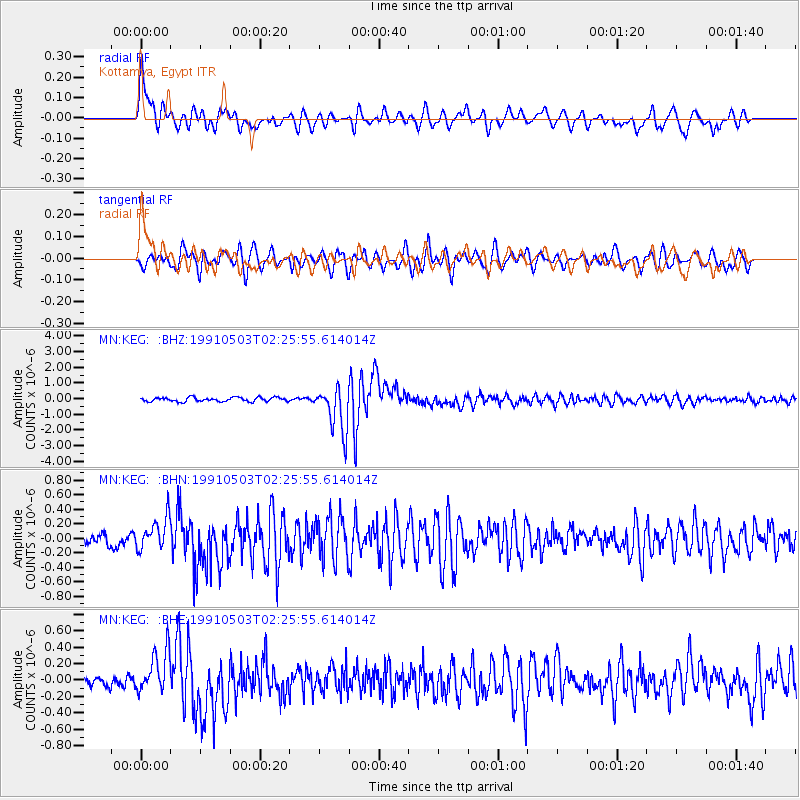
Signal To Noise
| Channel | StoN | STA | LTA |
| MN:KEG: :BHN:19910503T02:25:55.614014Z | 3.0245564 | 2.1845523E-7 | 7.2227195E-8 |
| MN:KEG: :BHE:19910503T02:25:55.614014Z | 3.4797647 | 2.589706E-7 | 7.442187E-8 |
| MN:KEG: :BHZ:19910503T02:25:55.614014Z | 11.061185 | 1.4436666E-6 | 1.3051645E-7 |
| Arrivals |
| Ps | 3.6 SECOND |
| PpPs | 13 SECOND |
| PsPs/PpSs | 17 SECOND |


