You are here: Home > Network List > MN - MEDNET Project Stations List
> Station KEG Kottamya, Egypt > Earthquake Result Viewer
KEG Kottamya, Egypt - Earthquake Result Viewer
| Earthquake location: |
Southeast Of Honshu, Japan |
| Earthquake latitude/longitude: |
32.5/141.7 |
| Earthquake time(UTC): |
1992/08/11 (224) 15:14:56 GMT |
| Earthquake Depth: |
28 km |
| Earthquake Magnitude: |
5.8 MB, 6.2 MS |
| Earthquake Catalog/Contributor: |
WHDF/NEIC |
|
| Network: |
MN MEDNET Project |
| Station: |
KEG Kottamya, Egypt |
| Lat/Lon: |
29.93 N/31.83 E |
| Elevation: |
460 m |
|
| Distance: |
89.1 deg |
| Az: |
305.259 deg |
| Baz: |
52.609 deg |
| Ray Param: |
0.042099636 |
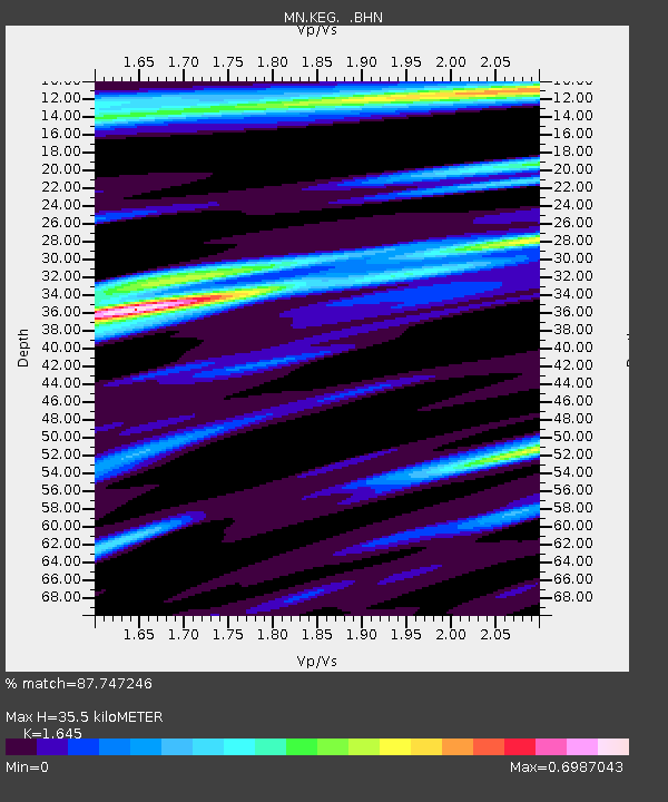
| Estimated Moho Depth: |
35.5 km |
| Estimated Crust Vp/Vs: |
1.64 |
| Assumed Crust Vp: |
6.312 km/s |
| Estimated Crust Vs: |
3.837 km/s |
| Estimated Crust Poisson's Ratio: |
0.21 |
|
| Radial Match: |
87.747246 % |
| Radial Bump: |
400 |
| Transverse Match: |
74.89115 % |
| Transverse Bump: |
400 |
| SOD ConfigId: |
16938 |
| Insert Time: |
2010-03-08 17:12:31.098 +0000 |
| GWidth: |
2.5 |
| Max Bumps: |
400 |
| Tol: |
0.001 |
|
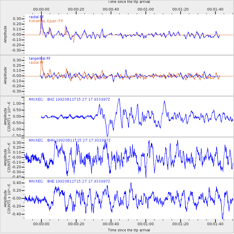
Signal To Noise
| Channel | StoN | STA | LTA |
| MN:KEG: :BHN:19920811T15:27:17.933997Z | 2.185704 | 1.17999456E-7 | 5.3986934E-8 |
| MN:KEG: :BHE:19920811T15:27:17.933997Z | 1.9460454 | 1.09612486E-7 | 5.6325757E-8 |
| MN:KEG: :BHZ:19920811T15:27:17.933997Z | 6.037038 | 4.1027008E-7 | 6.795884E-8 |
| Arrivals |
| Ps | 3.7 SECOND |
| PpPs | 15 SECOND |
| PsPs/PpSs | 18 SECOND |


