You are here: Home > Network List > MN - MEDNET Project Stations List
> Station KEG Kottamya, Egypt > Earthquake Result Viewer
KEG Kottamya, Egypt - Earthquake Result Viewer
| Earthquake location: |
Hokkaido, Japan Region |
| Earthquake latitude/longitude: |
42.8/139.2 |
| Earthquake time(UTC): |
1993/07/12 (193) 13:17:11 GMT |
| Earthquake Depth: |
17 km |
| Earthquake Magnitude: |
6.7 MB, 7.6 MS, 7.3 UNKNOWN, 7.8 MW |
| Earthquake Catalog/Contributor: |
WHDF/NEIC |
|
| Network: |
MN MEDNET Project |
| Station: |
KEG Kottamya, Egypt |
| Lat/Lon: |
29.93 N/31.83 E |
| Elevation: |
460 m |
|
| Distance: |
81.7 deg |
| Az: |
303.159 deg |
| Baz: |
45.178 deg |
| Ray Param: |
0.04742288 |
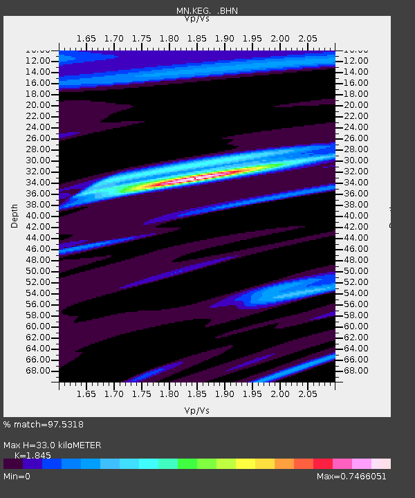
| Estimated Moho Depth: |
33.0 km |
| Estimated Crust Vp/Vs: |
1.85 |
| Assumed Crust Vp: |
6.312 km/s |
| Estimated Crust Vs: |
3.421 km/s |
| Estimated Crust Poisson's Ratio: |
0.29 |
|
| Radial Match: |
97.5318 % |
| Radial Bump: |
400 |
| Transverse Match: |
90.053894 % |
| Transverse Bump: |
400 |
| SOD ConfigId: |
16938 |
| Insert Time: |
2010-03-08 17:12:46.604 +0000 |
| GWidth: |
2.5 |
| Max Bumps: |
400 |
| Tol: |
0.001 |
|
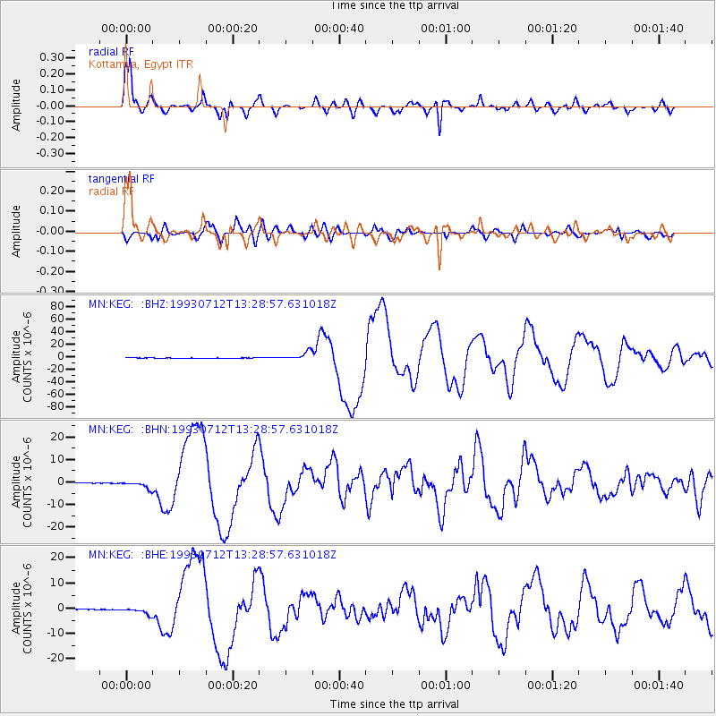
Signal To Noise
| Channel | StoN | STA | LTA |
| MN:KEG: :BHN:19930712T13:28:57.631018Z | 22.217674 | 1.6939089E-6 | 7.6241506E-8 |
| MN:KEG: :BHE:19930712T13:28:57.631018Z | 15.466359 | 1.4062775E-6 | 9.092492E-8 |
| MN:KEG: :BHZ:19930712T13:28:57.631018Z | 52.86792 | 6.7014284E-6 | 1.2675794E-7 |
| Arrivals |
| Ps | 4.5 SECOND |
| PpPs | 15 SECOND |
| PsPs/PpSs | 19 SECOND |


