KEG Kottamya, Egypt - Earthquake Result Viewer
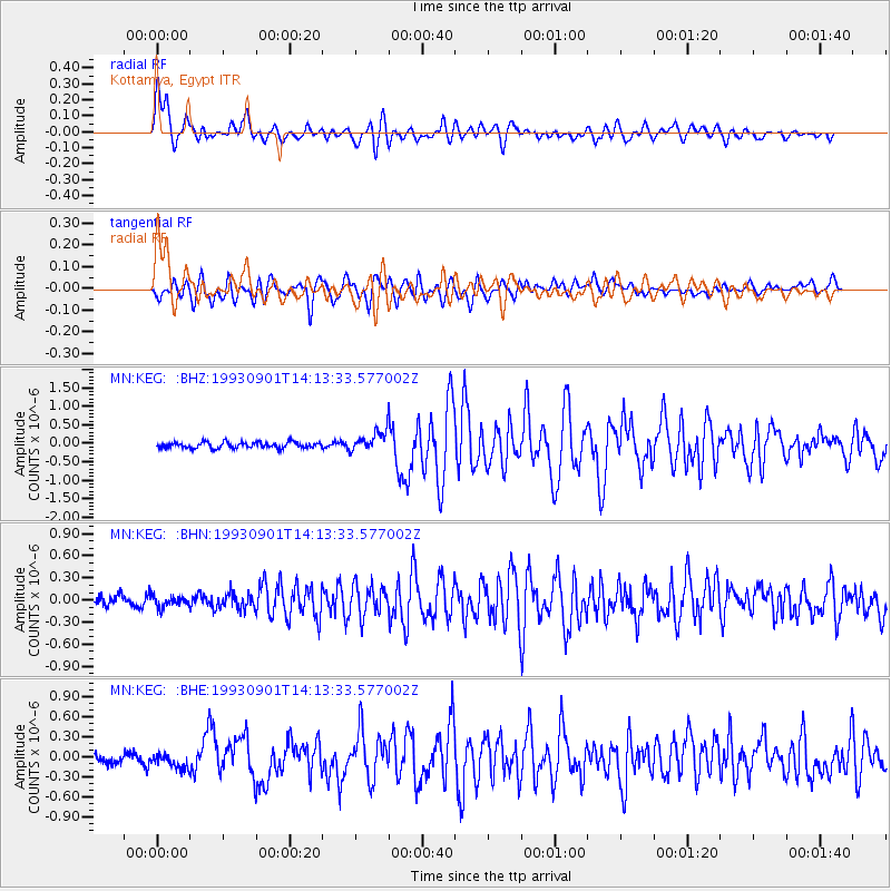
Earthquake location: Northern Sumatra, Indonesia
Earthquake latitude/longitude: 2.9/96.2
Earthquake time(UTC): 1993/09/01 (244) 14:03:18 GMT
Earthquake Depth: 33 km
Earthquake Magnitude: 5.8 MB, 6.2 MS, 6.0 UNKNOWN, 6.2 MW
Earthquake Catalog/Contributor: WHDF/NEIC
Network: MN MEDNET Project
Station: KEG Kottamya, Egypt
Lat/Lon: 29.93 N/31.83 E
Elevation: 460 m
Distance: 66.4 deg
Az: 301.346 deg
Baz: 100.728 deg
Ray Param: 0.057610348
Estimated Moho Depth: 11.75 km
Estimated Crust Vp/Vs: 1.80
Assumed Crust Vp: 6.312 km/s
Estimated Crust Vs: 3.512 km/s
Estimated Crust Poisson's Ratio: 0.28
Radial Match: 86.991585 %
Radial Bump: 400
Transverse Match: 82.598854 %
Transverse Bump: 400
SOD ConfigId: 16938
Insert Time: 2010-03-08 17:12:55.638 +0000
GWidth: 2.5
Max Bumps: 400
Tol: 0.001

Signal To Noise

ChannelStoNSTALTA
MN:KEG: :BHN:19930901T14:13:33.577002Z0.86902087.38128E-88.4937895E-8
MN:KEG: :BHE:19930901T14:13:33.577002Z1.45307541.1235321E-77.732098E-8
MN:KEG: :BHZ:19930901T14:13:33.577002Z3.36593442.7098352E-78.050766E-8
Arrivals
Ps1.5 SECOND
PpPs5.0 SECOND
PsPs/PpSs6.6 SECOND