You are here: Home > Network List > MN - MEDNET Project Stations List
> Station KEG Kottamya, Egypt > Earthquake Result Viewer
KEG Kottamya, Egypt - Earthquake Result Viewer
| Earthquake location: |
Minahassa Peninsula, Sulawesi |
| Earthquake latitude/longitude: |
0.5/121.6 |
| Earthquake time(UTC): |
1993/09/29 (272) 11:16:04 GMT |
| Earthquake Depth: |
103 km |
| Earthquake Magnitude: |
6.0 MB, 6.6 UNKNOWN |
| Earthquake Catalog/Contributor: |
WHDF/NEIC |
|
| Network: |
MN MEDNET Project |
| Station: |
KEG Kottamya, Egypt |
| Lat/Lon: |
29.93 N/31.83 E |
| Elevation: |
460 m |
|
| Distance: |
89.5 deg |
| Az: |
299.759 deg |
| Baz: |
89.67 deg |
| Ray Param: |
0.041719954 |
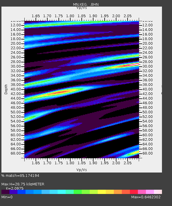
| Estimated Moho Depth: |
28.75 km |
| Estimated Crust Vp/Vs: |
2.10 |
| Assumed Crust Vp: |
6.312 km/s |
| Estimated Crust Vs: |
3.01 km/s |
| Estimated Crust Poisson's Ratio: |
0.35 |
|
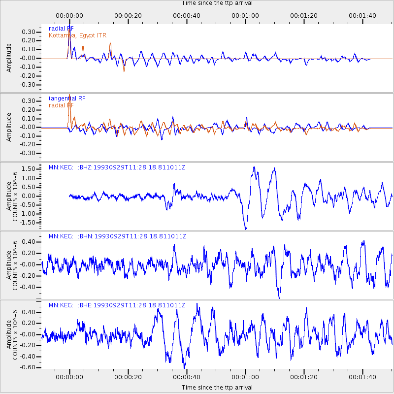
| Radial Match: |
85.174194 % |
| Radial Bump: |
400 |
| Transverse Match: |
81.4791 % |
| Transverse Bump: |
400 |
| SOD ConfigId: |
16938 |
| Insert Time: |
2010-03-08 17:12:59.255 +0000 |
| GWidth: |
2.5 |
| Max Bumps: |
400 |
| Tol: |
0.001 |
|
Signal To Noise
| Channel | StoN | STA | LTA |
| MN:KEG: :BHN:19930929T11:28:18.811011Z | 0.8998586 | 9.8567256E-8 | 1.0953638E-7 |
| MN:KEG: :BHE:19930929T11:28:18.811011Z | 1.6460801 | 1.0613824E-7 | 6.447939E-8 |
| MN:KEG: :BHZ:19930929T11:28:18.811011Z | 3.1247048 | 3.1490833E-7 | 1.0078018E-7 |
| Arrivals |
| Ps | 5.1 SECOND |
| PpPs | 14 SECOND |
| PsPs/PpSs | 19 SECOND |


