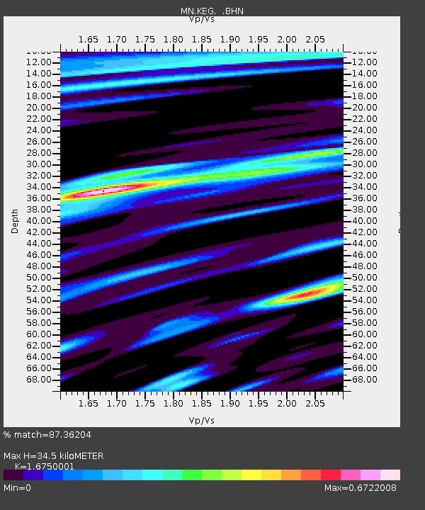
KEG Kottamya, Egypt - Earthquake Result Viewer
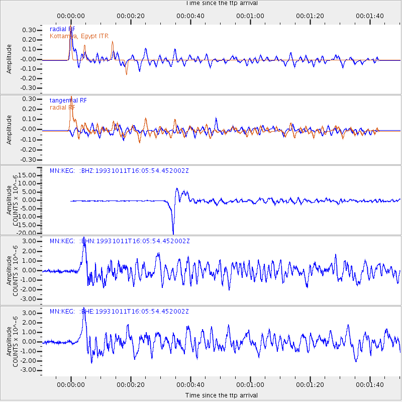
Earthquake location: Southeast Of Honshu, Japan
Earthquake latitude/longitude: 32.0/137.9
Earthquake time(UTC): 1993/10/11 (284) 15:54:22 GMT
Earthquake Depth: 365 km
Earthquake Magnitude: 6.5 MB, 6.8 UNKNOWN, 6.9 MW
Earthquake Catalog/Contributor: WHDF/NEIC
Network: MN MEDNET Project
Station: KEG Kottamya, Egypt
Lat/Lon: 29.93 N/31.83 E
Elevation: 460 m
Distance: 86.7 deg
Az: 303.301 deg
Baz: 54.885 deg
Ray Param: 0.042951774
Estimated Moho Depth: 34.5 km
Estimated Crust Vp/Vs: 1.68
Assumed Crust Vp: 6.312 km/s
Estimated Crust Vs: 3.769 km/s
Estimated Crust Poisson's Ratio: 0.22
Radial Match: 87.36204 %
Radial Bump: 400
Transverse Match: 73.57339 %
Transverse Bump: 400
SOD ConfigId: 16938
Insert Time: 2010-03-08 17:13:00.406 +0000
GWidth: 2.5
Max Bumps: 400
Tol: 0.001

Signal To Noise

ChannelStoNSTALTA
MN:KEG: :BHN:19931011T16:05:54.452002Z18.166551.232945E-66.786897E-8
MN:KEG: :BHE:19931011T16:05:54.452002Z17.080151.3359921E-67.821899E-8
MN:KEG: :BHZ:19931011T16:05:54.452002Z67.037996.2392705E-69.3070675E-8
Arrivals
Ps3.8 SECOND
PpPs14 SECOND
PsPs/PpSs18 SECOND