You are here: Home > Network List > MN - MEDNET Project Stations List
> Station KEG Kottamya, Egypt > Earthquake Result Viewer
KEG Kottamya, Egypt - Earthquake Result Viewer
| Earthquake location: |
Near East Coast Of Kamchatka |
| Earthquake latitude/longitude: |
51.8/158.7 |
| Earthquake time(UTC): |
1993/11/17 (321) 11:18:52 GMT |
| Earthquake Depth: |
44 km |
| Earthquake Magnitude: |
6.0 MB, 5.6 MS |
| Earthquake Catalog/Contributor: |
WHDF/NEIC |
|
| Network: |
MN MEDNET Project |
| Station: |
KEG Kottamya, Egypt |
| Lat/Lon: |
29.93 N/31.83 E |
| Elevation: |
460 m |
|
| Distance: |
86.2 deg |
| Az: |
315.895 deg |
| Baz: |
29.854 deg |
| Ray Param: |
0.044129603 |
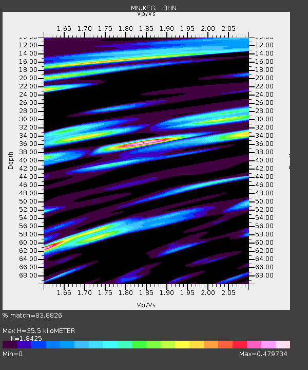
| Estimated Moho Depth: |
35.5 km |
| Estimated Crust Vp/Vs: |
1.84 |
| Assumed Crust Vp: |
6.312 km/s |
| Estimated Crust Vs: |
3.426 km/s |
| Estimated Crust Poisson's Ratio: |
0.29 |
|
| Radial Match: |
83.8826 % |
| Radial Bump: |
400 |
| Transverse Match: |
78.543526 % |
| Transverse Bump: |
400 |
| SOD ConfigId: |
16938 |
| Insert Time: |
2010-03-08 17:13:01.765 +0000 |
| GWidth: |
2.5 |
| Max Bumps: |
400 |
| Tol: |
0.001 |
|

Signal To Noise
| Channel | StoN | STA | LTA |
| MN:KEG: :BHN:19931117T11:30:58.605017Z | 3.5332503 | 3.367168E-7 | 9.529944E-8 |
| MN:KEG: :BHE:19931117T11:30:58.605017Z | 2.5043821 | 2.0755931E-7 | 8.287845E-8 |
| MN:KEG: :BHZ:19931117T11:30:58.605017Z | 13.179158 | 1.7014282E-6 | 1.2909992E-7 |
| Arrivals |
| Ps | 4.8 SECOND |
| PpPs | 16 SECOND |
| PsPs/PpSs | 20 SECOND |


