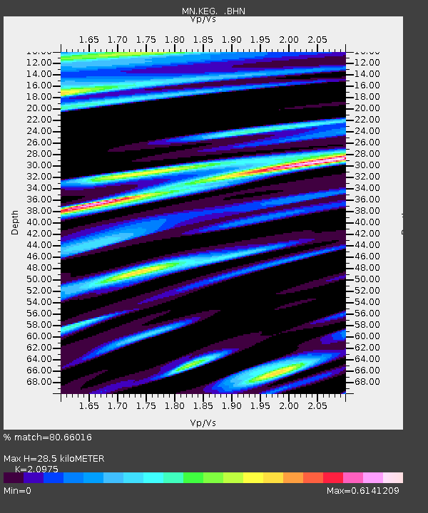
KEG Kottamya, Egypt - Earthquake Result Viewer
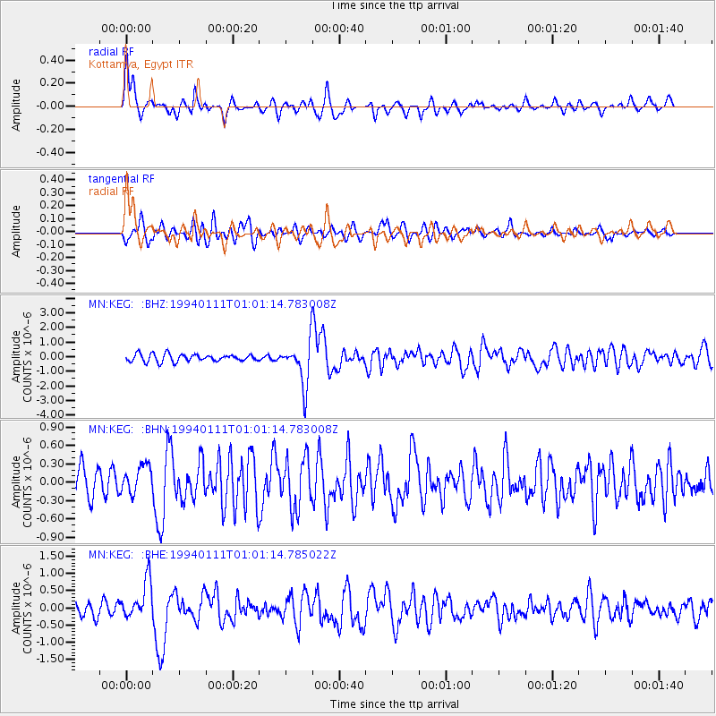
Earthquake location: Myanmar-China Border Region
Earthquake latitude/longitude: 25.2/97.2
Earthquake time(UTC): 1994/01/11 (011) 00:51:59 GMT
Earthquake Depth: 33 km
Earthquake Magnitude: 5.9 MB, 5.9 MS, 5.6 UNKNOWN, 6.1 MW
Earthquake Catalog/Contributor: WHDF/NEIC
Network: MN MEDNET Project
Station: KEG Kottamya, Egypt
Lat/Lon: 29.93 N/31.83 E
Elevation: 460 m
Distance: 57.5 deg
Az: 290.595 deg
Baz: 77.644 deg
Ray Param: 0.06341109
Estimated Moho Depth: 28.5 km
Estimated Crust Vp/Vs: 2.10
Assumed Crust Vp: 6.312 km/s
Estimated Crust Vs: 3.01 km/s
Estimated Crust Poisson's Ratio: 0.35
Radial Match: 80.66016 %
Radial Bump: 400
Transverse Match: 69.23305 %
Transverse Bump: 400
SOD ConfigId: 16938
Insert Time: 2010-03-08 17:13:05.484 +0000
GWidth: 2.5
Max Bumps: 400
Tol: 0.001

Signal To Noise

ChannelStoNSTALTA
MN:KEG: :BHN:19940111T01:01:14.783008Z1.12110512.3006385E-72.0521166E-7
MN:KEG: :BHE:19940111T01:01:14.785022Z3.3945925.6523095E-71.6650924E-7
MN:KEG: :BHZ:19940111T01:01:14.783008Z5.79485751.4764273E-62.5478232E-7
Arrivals
Ps5.2 SECOND
PpPs13 SECOND
PsPs/PpSs19 SECOND