You are here: Home > Network List > MN - MEDNET Project Stations List
> Station KEG Kottamya, Egypt > Earthquake Result Viewer
KEG Kottamya, Egypt - Earthquake Result Viewer
| Earthquake location: |
Southern Sumatra, Indonesia |
| Earthquake latitude/longitude: |
-4.8/103.7 |
| Earthquake time(UTC): |
1994/01/21 (021) 18:00:17 GMT |
| Earthquake Depth: |
89 km |
| Earthquake Magnitude: |
6.0 MB |
| Earthquake Catalog/Contributor: |
WHDF/NEIC |
|
| Network: |
MN MEDNET Project |
| Station: |
KEG Kottamya, Egypt |
| Lat/Lon: |
29.93 N/31.83 E |
| Elevation: |
460 m |
|
| Distance: |
76.9 deg |
| Az: |
302.077 deg |
| Baz: |
103.425 deg |
| Ray Param: |
0.050507214 |
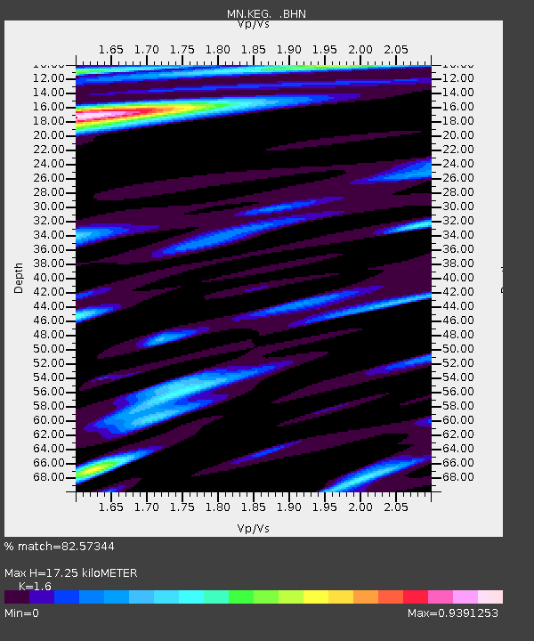
| Estimated Moho Depth: |
17.25 km |
| Estimated Crust Vp/Vs: |
1.60 |
| Assumed Crust Vp: |
6.312 km/s |
| Estimated Crust Vs: |
3.945 km/s |
| Estimated Crust Poisson's Ratio: |
0.18 |
|
| Radial Match: |
82.57344 % |
| Radial Bump: |
400 |
| Transverse Match: |
71.63427 % |
| Transverse Bump: |
400 |
| SOD ConfigId: |
16938 |
| Insert Time: |
2010-03-08 17:13:06.699 +0000 |
| GWidth: |
2.5 |
| Max Bumps: |
400 |
| Tol: |
0.001 |
|
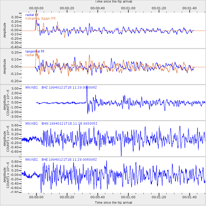
Signal To Noise
| Channel | StoN | STA | LTA |
| MN:KEG: :BHN:19940121T18:11:28.993005Z | 1.5346289 | 1.1964558E-7 | 7.796385E-8 |
| MN:KEG: :BHE:19940121T18:11:29.006006Z | 3.0264025 | 2.3922303E-7 | 7.904534E-8 |
| MN:KEG: :BHZ:19940121T18:11:29.006006Z | 13.6571245 | 1.0902238E-6 | 7.982821E-8 |
| Arrivals |
| Ps | 1.7 SECOND |
| PpPs | 6.9 SECOND |
| PsPs/PpSs | 8.6 SECOND |


