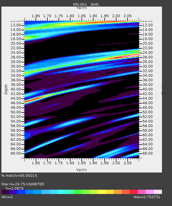
KEG Kottamya, Egypt - Earthquake Result Viewer
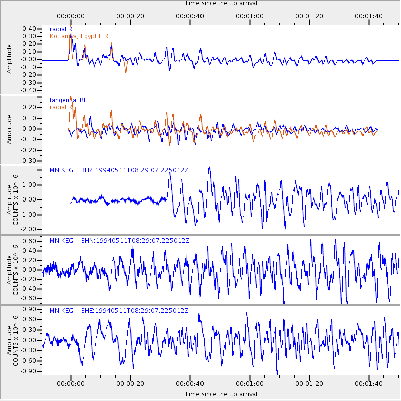
Earthquake location: Southern Sumatra, Indonesia
Earthquake latitude/longitude: -2.0/99.8
Earthquake time(UTC): 1994/05/11 (131) 08:18:16 GMT
Earthquake Depth: 28 km
Earthquake Magnitude: 6.0 MB, 6.3 MS, 6.0 UNKNOWN, 6.3 MW
Earthquake Catalog/Contributor: WHDF/NEIC
Network: MN MEDNET Project
Station: KEG Kottamya, Egypt
Lat/Lon: 29.93 N/31.83 E
Elevation: 460 m
Distance: 72.0 deg
Az: 302.231 deg
Baz: 103.131 deg
Ray Param: 0.053883824
Estimated Moho Depth: 24.75 km
Estimated Crust Vp/Vs: 2.10
Assumed Crust Vp: 6.312 km/s
Estimated Crust Vs: 3.01 km/s
Estimated Crust Poisson's Ratio: 0.35
Radial Match: 88.85015 %
Radial Bump: 400
Transverse Match: 81.31016 %
Transverse Bump: 400
SOD ConfigId: 16938
Insert Time: 2010-03-08 17:13:11.801 +0000
GWidth: 2.5
Max Bumps: 400
Tol: 0.001

Signal To Noise

ChannelStoNSTALTA
MN:KEG: :BHN:19940511T08:29:07.225012Z1.51964141.2282565E-78.0825416E-8
MN:KEG: :BHE:19940511T08:29:07.225012Z2.83923582.8945766E-71.0194914E-7
MN:KEG: :BHZ:19940511T08:29:07.225012Z7.41815147.370935E-79.9363504E-8
Arrivals
Ps4.4 SECOND
PpPs12 SECOND
PsPs/PpSs16 SECOND