You are here: Home > Network List > MN - MEDNET Project Stations List
> Station KEG Kottamya, Egypt > Earthquake Result Viewer
KEG Kottamya, Egypt - Earthquake Result Viewer
| Earthquake location: |
Myanmar |
| Earthquake latitude/longitude: |
20.5/94.2 |
| Earthquake time(UTC): |
1994/05/29 (149) 14:11:51 GMT |
| Earthquake Depth: |
42 km |
| Earthquake Magnitude: |
6.2 MB, 6.2 MS, 5.9 UNKNOWN, 6.5 MW |
| Earthquake Catalog/Contributor: |
WHDF/NEIC |
|
| Network: |
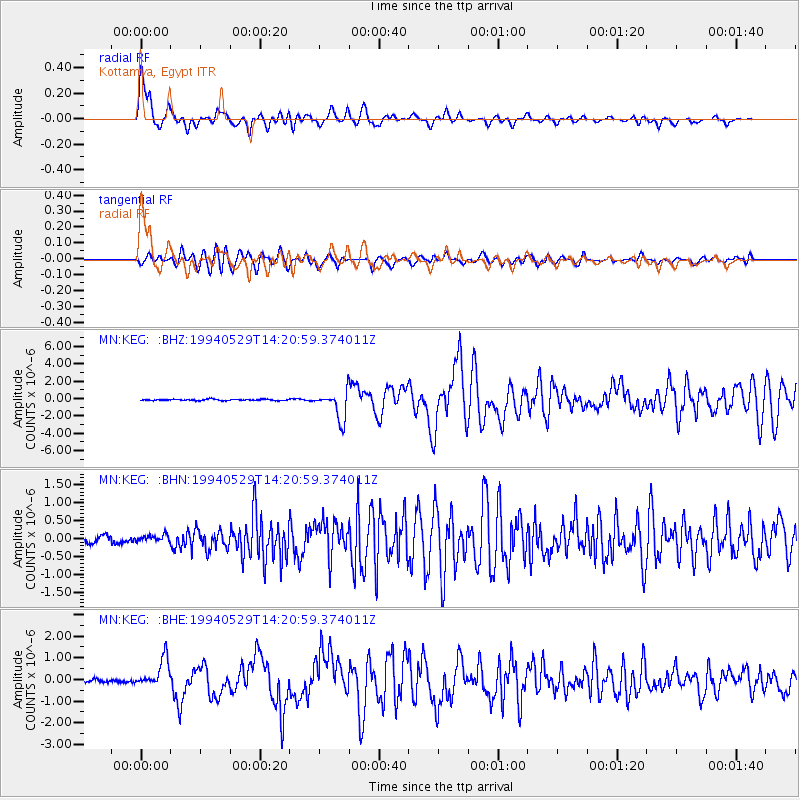
MN MEDNET Project |
| Station: |
KEG Kottamya, Egypt |
| Lat/Lon: |
29.93 N/31.83 E |
| Elevation: |
460 m |
|
| Distance: |
56.6 deg |
| Az: |
292.889 deg |
| Baz: |
84.036 deg |
| Ray Param: |
0.06397169 |
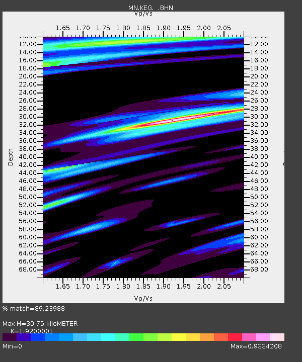
| Estimated Moho Depth: |
30.75 km |
| Estimated Crust Vp/Vs: |
1.92 |
| Assumed Crust Vp: |
6.312 km/s |
| Estimated Crust Vs: |
3.288 km/s |
| Estimated Crust Poisson's Ratio: |
0.31 |
|
| Radial Match: |
89.23988 % |
| Radial Bump: |
400 |
| Transverse Match: |
82.07824 % |
| Transverse Bump: |
400 |
| SOD ConfigId: |
16938 |
| Insert Time: |
2010-03-08 17:13:19.978 +0000 |
| GWidth: |
2.5 |
| Max Bumps: |
400 |
| Tol: |
0.001 |
|
Signal To Noise
| Channel | StoN | STA | LTA |
| MN:KEG: :BHN:19940529T14:20:59.374011Z | 1.4456774 | 1.0097509E-7 | 6.9846216E-8 |
| MN:KEG: :BHE:19940529T14:20:59.374011Z | 9.777364 | 6.5059254E-7 | 6.654069E-8 |
| MN:KEG: :BHZ:19940529T14:20:59.374011Z | 22.507664 | 1.628741E-6 | 7.236384E-8 |
| Arrivals |
| Ps | 4.7 SECOND |
| PpPs | 14 SECOND |
| PsPs/PpSs | 18 SECOND |


