You are here: Home > Network List > MN - MEDNET Project Stations List
> Station KEG Kottamya, Egypt > Earthquake Result Viewer
KEG Kottamya, Egypt - Earthquake Result Viewer
| Earthquake location: |
East Of Kuril Islands |
| Earthquake latitude/longitude: |
44.7/150.1 |
| Earthquake time(UTC): |
1994/08/14 (226) 00:46:22 GMT |
| Earthquake Depth: |
33 km |
| Earthquake Magnitude: |
5.9 MB, 5.8 MS, 5.4 UNKNOWN, 6.1 MW |
| Earthquake Catalog/Contributor: |
WHDF/NEIC |
|
| Network: |
MN MEDNET Project |
| Station: |
KEG Kottamya, Egypt |
| Lat/Lon: |
29.93 N/31.83 E |
| Elevation: |
460 m |
|
| Distance: |
86.9 deg |
| Az: |
310.051 deg |
| Baz: |
39.0 deg |
| Ray Param: |
0.04366808 |
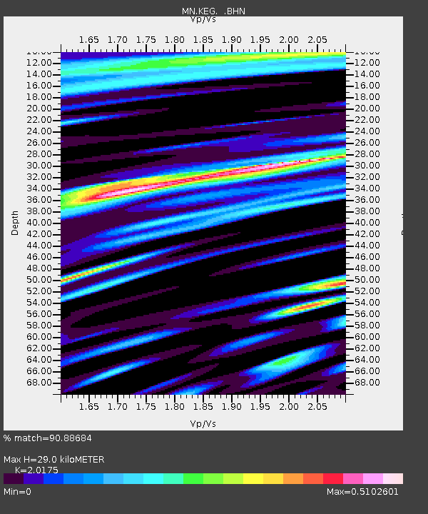
| Estimated Moho Depth: |
29.0 km |
| Estimated Crust Vp/Vs: |
2.02 |
| Assumed Crust Vp: |
6.312 km/s |
| Estimated Crust Vs: |
3.129 km/s |
| Estimated Crust Poisson's Ratio: |
0.34 |
|
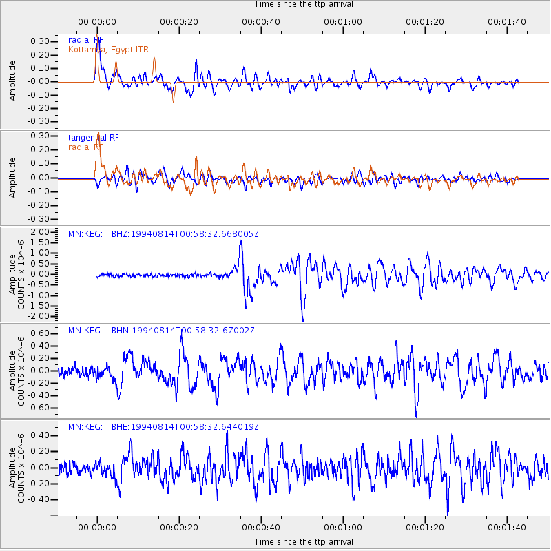
| Radial Match: |
90.88684 % |
| Radial Bump: |
400 |
| Transverse Match: |
79.68215 % |
| Transverse Bump: |
400 |
| SOD ConfigId: |
16938 |
| Insert Time: |
2010-03-08 17:13:27.095 +0000 |
| GWidth: |
2.5 |
| Max Bumps: |
400 |
| Tol: |
0.001 |
|
Signal To Noise
| Channel | StoN | STA | LTA |
| MN:KEG: :BHN:19940814T00:58:32.67002Z | 1.8501297 | 1.0313473E-7 | 5.5744593E-8 |
| MN:KEG: :BHE:19940814T00:58:32.644019Z | 1.2513824 | 8.359826E-8 | 6.680473E-8 |
| MN:KEG: :BHZ:19940814T00:58:32.668005Z | 6.535212 | 3.3753872E-7 | 5.1649238E-8 |
| Arrivals |
| Ps | 4.8 SECOND |
| PpPs | 14 SECOND |
| PsPs/PpSs | 18 SECOND |


