You are here: Home > Network List > MN - MEDNET Project Stations List
> Station KEG Kottamya, Egypt > Earthquake Result Viewer
KEG Kottamya, Egypt - Earthquake Result Viewer
| Earthquake location: |
Ryukyu Islands, Japan |
| Earthquake latitude/longitude: |
29.3/129.9 |
| Earthquake time(UTC): |
1994/09/13 (256) 04:28:01 GMT |
| Earthquake Depth: |
37 km |
| Earthquake Magnitude: |
5.8 MB, 6.3 MS, 6.2 UNKNOWN, 6.1 MW |
| Earthquake Catalog/Contributor: |
WHDF/NEIC |
|
| Network: |
MN MEDNET Project |
| Station: |
KEG Kottamya, Egypt |
| Lat/Lon: |
29.93 N/31.83 E |
| Elevation: |
460 m |
|
| Distance: |
82.2 deg |
| Az: |
299.82 deg |
| Baz: |
60.84 deg |
| Ray Param: |
0.046988867 |
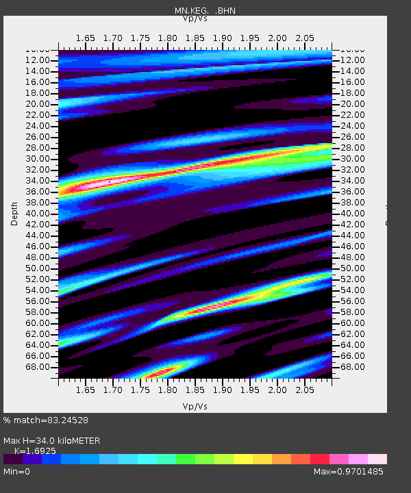
| Estimated Moho Depth: |
34.0 km |
| Estimated Crust Vp/Vs: |
1.69 |
| Assumed Crust Vp: |
6.312 km/s |
| Estimated Crust Vs: |
3.73 km/s |
| Estimated Crust Poisson's Ratio: |
0.23 |
|
| Radial Match: |
83.24528 % |
| Radial Bump: |
400 |
| Transverse Match: |
78.35762 % |
| Transverse Bump: |
400 |
| SOD ConfigId: |
17000 |
| Insert Time: |
2010-03-08 17:13:43.144 +0000 |
| GWidth: |
2.5 |
| Max Bumps: |
400 |
| Tol: |
0.001 |
|

Signal To Noise
| Channel | StoN | STA | LTA |
| MN:KEG: :BHN:19940913T04:39:47.215027Z | 1.5869215 | 1.5445785E-7 | 9.733176E-8 |
| MN:KEG: :BHE:19940913T04:39:47.215027Z | 2.3922439 | 2.1036075E-7 | 8.793449E-8 |
| MN:KEG: :BHZ:19940913T04:39:47.215027Z | 3.68947 | 4.985355E-7 | 1.3512387E-7 |
| Arrivals |
| Ps | 3.8 SECOND |
| PpPs | 14 SECOND |
| PsPs/PpSs | 18 SECOND |


