You are here: Home > Network List > CN - Canadian National Seismograph Network Stations List
> Station INK INUVIK, NT > Earthquake Result Viewer
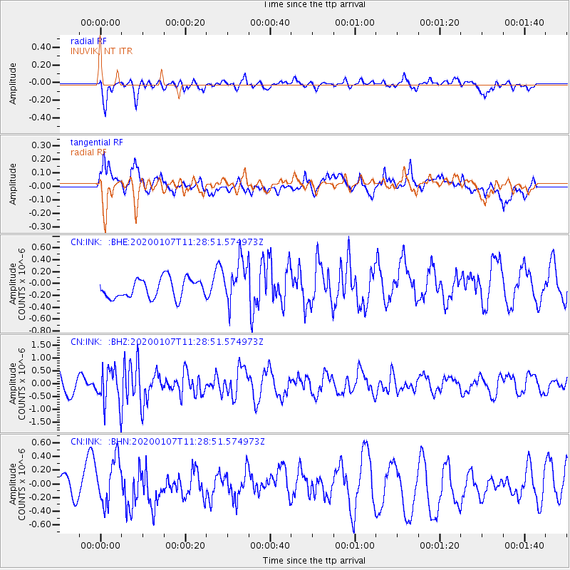
INK INUVIK, NT - Earthquake Result Viewer
*The percent match for this event was below the threshold and hence no stack was calculated.
| Earthquake location: |
Puerto Rico Region |
| Earthquake latitude/longitude: |
18.0/-66.8 |
| Earthquake time(UTC): |
2020/01/07 (007) 11:18:43 GMT |
| Earthquake Depth: |
9.0 km |
| Earthquake Magnitude: |
5.8 Mww |
| Earthquake Catalog/Contributor: |
NEIC PDE/pr |
|
| Network: |
CN Canadian National Seismograph Network |
| Station: |
INK INUVIK, NT |
| Lat/Lon: |
68.31 N/133.53 W |
| Elevation: |
44 m |
|
| Distance: |
64.8 deg |
| Az: |
337.827 deg |
| Baz: |
105.007 deg |
| Ray Param: |
$rayparam |
*The percent match for this event was below the threshold and hence was not used in the summary stack. |
|
| Radial Match: |
71.960526 % |
| Radial Bump: |
400 |
| Transverse Match: |
68.17417 % |
| Transverse Bump: |
400 |
| SOD ConfigId: |
20465011 |
| Insert Time: |
2020-01-21 11:37:20.011 +0000 |
| GWidth: |
2.5 |
| Max Bumps: |
400 |
| Tol: |
0.001 |
|
Signal To Noise
| Channel | StoN | STA | LTA |
| CN:INK: :BHZ:20200107T11:28:51.574973Z | 2.3382003 | 7.185283E-7 | 3.0729973E-7 |
| CN:INK: :BHN:20200107T11:28:51.574973Z | 2.127619 | 3.3426136E-7 | 1.5710583E-7 |
| CN:INK: :BHE:20200107T11:28:51.574973Z | 2.2996325 | 3.7533772E-7 | 1.6321638E-7 |
| Arrivals |
| Ps | |
| PpPs | |
| PsPs/PpSs | |


