You are here: Home > Network List > MN - MEDNET Project Stations List
> Station KEG Kottamya, Egypt > Earthquake Result Viewer
KEG Kottamya, Egypt - Earthquake Result Viewer
| Earthquake location: |
Kuril Islands |
| Earthquake latitude/longitude: |
43.7/147.3 |
| Earthquake time(UTC): |
1994/10/04 (277) 13:22:58 GMT |
| Earthquake Depth: |
33 km |
| Earthquake Magnitude: |
7.4 MB, 8.1 MS, 8.3 UNKNOWN, 8.2 MW |
| Earthquake Catalog/Contributor: |
WHDF/NEIC |
|
| Network: |
MN MEDNET Project |
| Station: |
KEG Kottamya, Egypt |
| Lat/Lon: |
29.93 N/31.83 E |
| Elevation: |
460 m |
|
| Distance: |
85.9 deg |
| Az: |
308.232 deg |
| Baz: |
41.012 deg |
| Ray Param: |
0.04436141 |
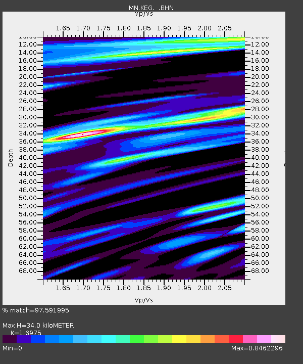
| Estimated Moho Depth: |
34.0 km |
| Estimated Crust Vp/Vs: |
1.70 |
| Assumed Crust Vp: |
6.312 km/s |
| Estimated Crust Vs: |
3.719 km/s |
| Estimated Crust Poisson's Ratio: |
0.23 |
|
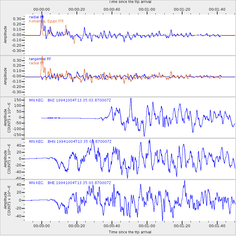
| Radial Match: |
97.591995 % |
| Radial Bump: |
400 |
| Transverse Match: |
93.668594 % |
| Transverse Bump: |
400 |
| SOD ConfigId: |
17000 |
| Insert Time: |
2010-03-08 17:13:47.379 +0000 |
| GWidth: |
2.5 |
| Max Bumps: |
400 |
| Tol: |
0.001 |
|
Signal To Noise
| Channel | StoN | STA | LTA |
| MN:KEG: :BHN:19941004T13:35:03.870007Z | 4.447745 | 2.9399912E-6 | 6.6100716E-7 |
| MN:KEG: :BHE:19941004T13:35:03.870007Z | 4.4743137 | 2.0814955E-6 | 4.6521E-7 |
| MN:KEG: :BHZ:19941004T13:35:03.870007Z | 5.5668874 | 5.4704105E-6 | 9.826696E-7 |
| Arrivals |
| Ps | 3.8 SECOND |
| PpPs | 14 SECOND |
| PsPs/PpSs | 18 SECOND |


