You are here: Home > Network List > MN - MEDNET Project Stations List
> Station KEG Kottamya, Egypt > Earthquake Result Viewer
KEG Kottamya, Egypt - Earthquake Result Viewer
| Earthquake location: |
Kuril Islands |
| Earthquake latitude/longitude: |
43.9/147.8 |
| Earthquake time(UTC): |
1994/10/04 (277) 13:52:46 GMT |
| Earthquake Depth: |
33 km |
| Earthquake Magnitude: |
5.9 MB |
| Earthquake Catalog/Contributor: |
WHDF/NEIC |
|
| Network: |
MN MEDNET Project |
| Station: |
KEG Kottamya, Egypt |
| Lat/Lon: |
29.93 N/31.83 E |
| Elevation: |
460 m |
|
| Distance: |
86.1 deg |
| Az: |
308.543 deg |
| Baz: |
40.611 deg |
| Ray Param: |
0.044264734 |
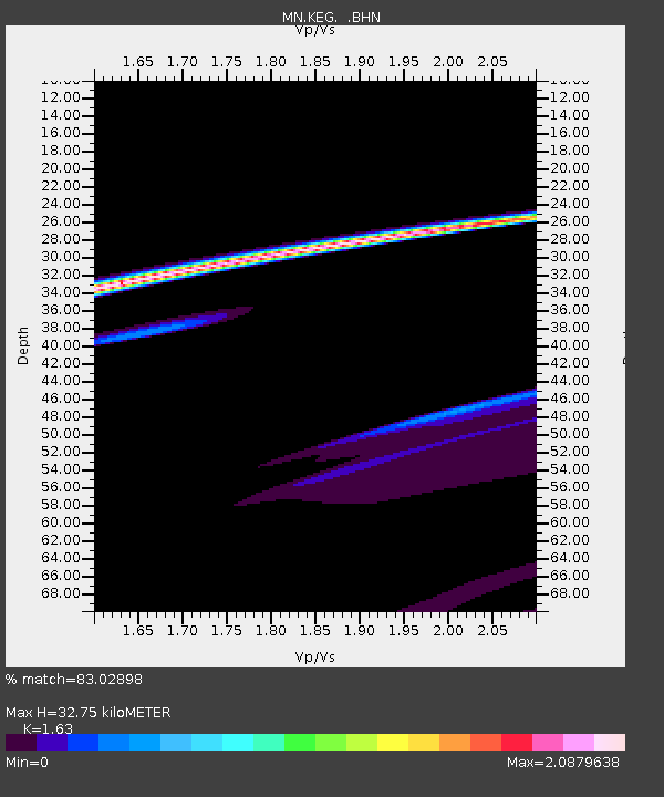
| Estimated Moho Depth: |
32.75 km |
| Estimated Crust Vp/Vs: |
1.63 |
| Assumed Crust Vp: |
6.312 km/s |
| Estimated Crust Vs: |
3.873 km/s |
| Estimated Crust Poisson's Ratio: |
0.20 |
|
| Radial Match: |
83.02898 % |
| Radial Bump: |
400 |
| Transverse Match: |
32.857857 % |
| Transverse Bump: |
243 |
| SOD ConfigId: |
17000 |
| Insert Time: |
2010-03-08 17:13:48.670 +0000 |
| GWidth: |
2.5 |
| Max Bumps: |
400 |
| Tol: |
0.001 |
|
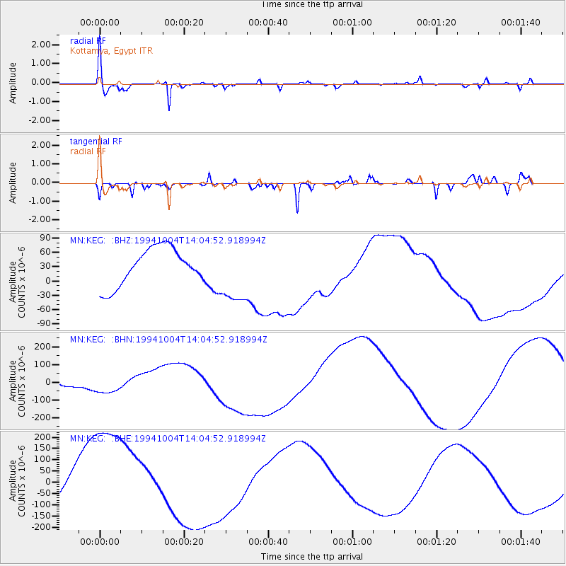
Signal To Noise
| Channel | StoN | STA | LTA |
| MN:KEG: :BHN:19941004T14:04:52.918994Z | 1.9906077 | 7.1217975E-5 | 3.5777E-5 |
| MN:KEG: :BHE:19941004T14:04:52.918994Z | 3.794314 | 2.8681112E-4 | 7.558972E-5 |
| MN:KEG: :BHZ:19941004T14:04:52.918994Z | 1.7121671 | 6.672023E-5 | 3.8968294E-5 |
| Arrivals |
| Ps | 3.3 SECOND |
| PpPs | 13 SECOND |
| PsPs/PpSs | 17 SECOND |


