You are here: Home > Network List > MN - MEDNET Project Stations List
> Station KEG Kottamya, Egypt > Earthquake Result Viewer
KEG Kottamya, Egypt - Earthquake Result Viewer
| Earthquake location: |
Kuril Islands |
| Earthquake latitude/longitude: |
45.7/149.2 |
| Earthquake time(UTC): |
1994/10/16 (289) 05:10:03 GMT |
| Earthquake Depth: |
139 km |
| Earthquake Magnitude: |
6.3 MB, 6.8 UNKNOWN, 6.7 MW |
| Earthquake Catalog/Contributor: |
WHDF/NEIC |
|
| Network: |
MN MEDNET Project |
| Station: |
KEG Kottamya, Egypt |
| Lat/Lon: |
29.93 N/31.83 E |
| Elevation: |
460 m |
|
| Distance: |
85.7 deg |
| Az: |
309.383 deg |
| Baz: |
38.574 deg |
| Ray Param: |
0.044254757 |
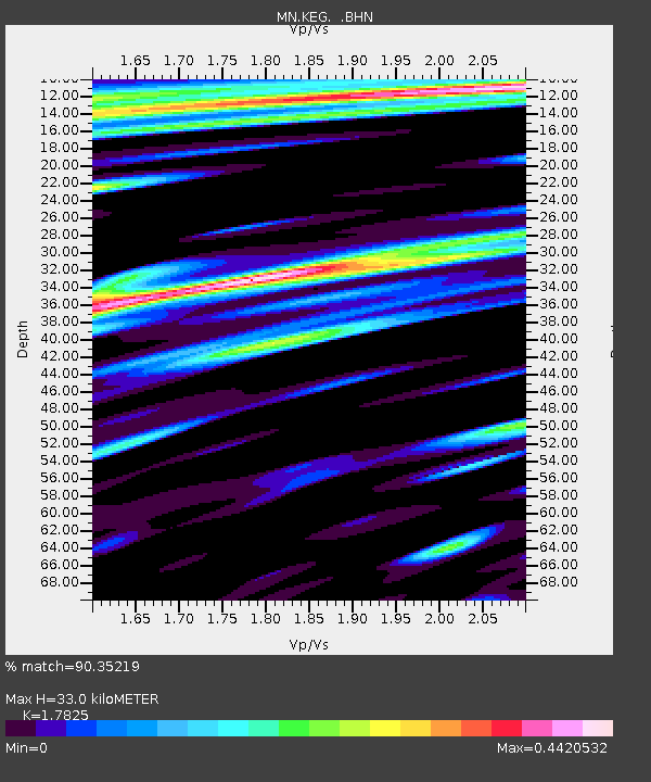
| Estimated Moho Depth: |
33.0 km |
| Estimated Crust Vp/Vs: |
1.78 |
| Assumed Crust Vp: |
6.312 km/s |
| Estimated Crust Vs: |
3.541 km/s |
| Estimated Crust Poisson's Ratio: |
0.27 |
|
| Radial Match: |
90.35219 % |
| Radial Bump: |
400 |
| Transverse Match: |
81.433365 % |
| Transverse Bump: |
400 |
| SOD ConfigId: |
17000 |
| Insert Time: |
2010-03-08 17:13:54.475 +0000 |
| GWidth: |
2.5 |
| Max Bumps: |
400 |
| Tol: |
0.001 |
|
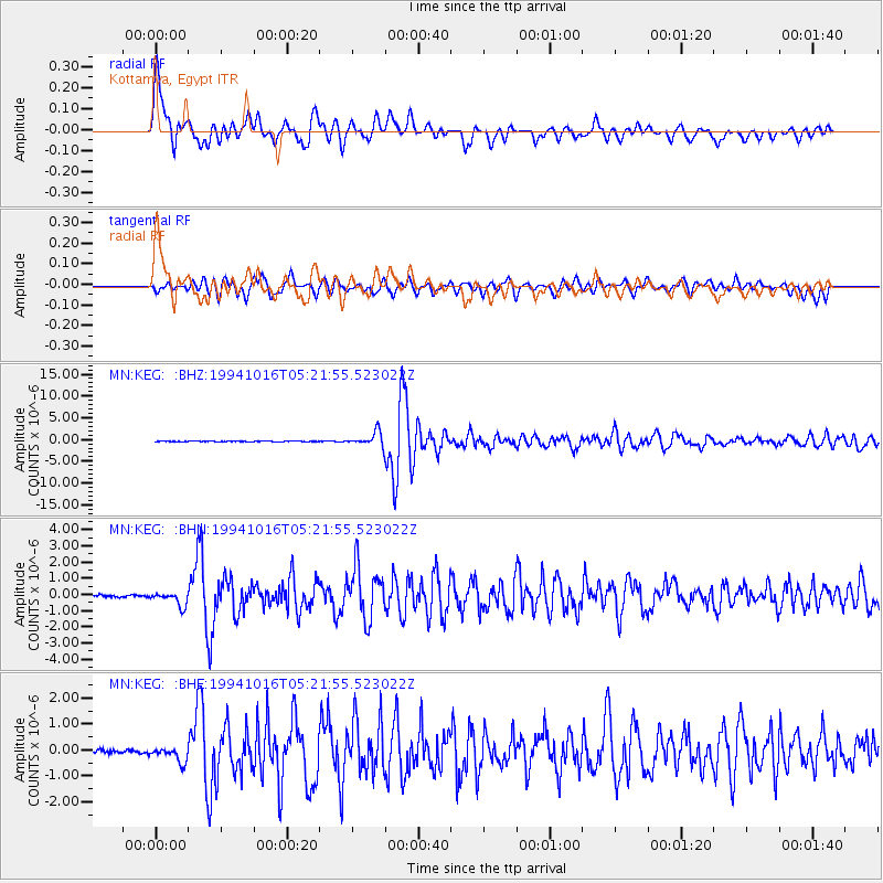
Signal To Noise
| Channel | StoN | STA | LTA |
| MN:KEG: :BHN:19941016T05:21:55.523022Z | 7.169342 | 4.2834932E-7 | 5.974737E-8 |
| MN:KEG: :BHE:19941016T05:21:55.523022Z | 5.349901 | 2.8093726E-7 | 5.2512604E-8 |
| MN:KEG: :BHZ:19941016T05:21:55.523022Z | 24.336792 | 1.6129699E-6 | 6.627701E-8 |
| Arrivals |
| Ps | 4.2 SECOND |
| PpPs | 14 SECOND |
| PsPs/PpSs | 18 SECOND |


