You are here: Home > Network List > MN - MEDNET Project Stations List
> Station KEG Kottamya, Egypt > Earthquake Result Viewer
KEG Kottamya, Egypt - Earthquake Result Viewer
| Earthquake location: |
Off East Coast Of Honshu, Japan |
| Earthquake latitude/longitude: |
40.3/143.7 |
| Earthquake time(UTC): |
1994/12/28 (362) 12:59:53 GMT |
| Earthquake Depth: |
33 km |
| Earthquake Magnitude: |
5.7 MB |
| Earthquake Catalog/Contributor: |
WHDF/NEIC |
|
| Network: |
MN MEDNET Project |
| Station: |
KEG Kottamya, Egypt |
| Lat/Lon: |
29.93 N/31.83 E |
| Elevation: |
460 m |
|
| Distance: |
85.9 deg |
| Az: |
306.134 deg |
| Baz: |
45.395 deg |
| Ray Param: |
0.04440949 |
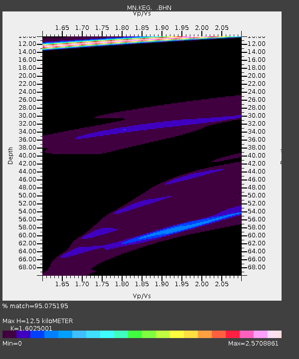
| Estimated Moho Depth: |
12.5 km |
| Estimated Crust Vp/Vs: |
1.60 |
| Assumed Crust Vp: |
6.312 km/s |
| Estimated Crust Vs: |
3.939 km/s |
| Estimated Crust Poisson's Ratio: |
0.18 |
|
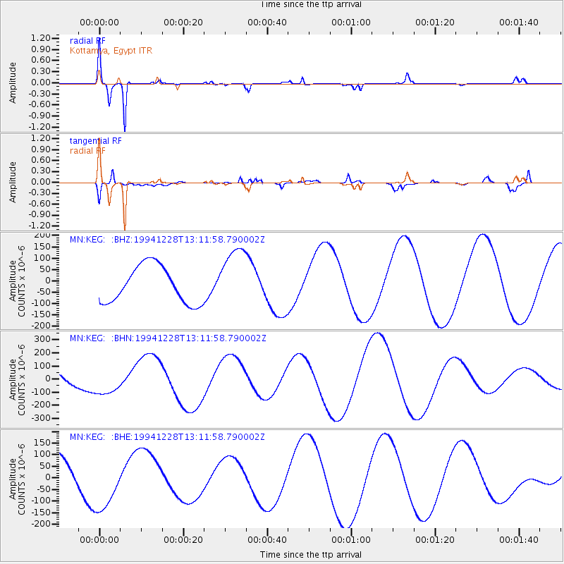
| Radial Match: |
95.075195 % |
| Radial Bump: |
248 |
| Transverse Match: |
61.452885 % |
| Transverse Bump: |
400 |
| SOD ConfigId: |
17000 |
| Insert Time: |
2010-03-08 17:13:58.540 +0000 |
| GWidth: |
2.5 |
| Max Bumps: |
400 |
| Tol: |
0.001 |
|
Signal To Noise
| Channel | StoN | STA | LTA |
| MN:KEG: :BHN:19941228T13:11:58.790002Z | 1.0074639 | 9.4671515E-5 | 9.397013E-5 |
| MN:KEG: :BHE:19941228T13:11:58.790002Z | 1.7471297 | 1.2365745E-4 | 7.077749E-5 |
| MN:KEG: :BHZ:19941228T13:11:58.790002Z | 1.7106944 | 1.3854218E-4 | 8.098592E-5 |
| Arrivals |
| Ps | 1.2 SECOND |
| PpPs | 5.0 SECOND |
| PsPs/PpSs | 6.2 SECOND |


