You are here: Home > Network List > MN - MEDNET Project Stations List
> Station KEG Kottamya, Egypt > Earthquake Result Viewer
KEG Kottamya, Egypt - Earthquake Result Viewer
| Earthquake location: |
Myanmar-India Border Region |
| Earthquake latitude/longitude: |
25.0/95.3 |
| Earthquake time(UTC): |
1995/05/06 (126) 01:59:07 GMT |
| Earthquake Depth: |
122 km |
| Earthquake Magnitude: |
6.4 MB, 6.5 UNKNOWN, 6.4 MW |
| Earthquake Catalog/Contributor: |
WHDF/NEIC |
|
| Network: |
MN MEDNET Project |
| Station: |
KEG Kottamya, Egypt |
| Lat/Lon: |
29.93 N/31.83 E |
| Elevation: |
460 m |
|
| Distance: |
55.9 deg |
| Az: |
290.312 deg |
| Baz: |
78.58 deg |
| Ray Param: |
0.064086445 |
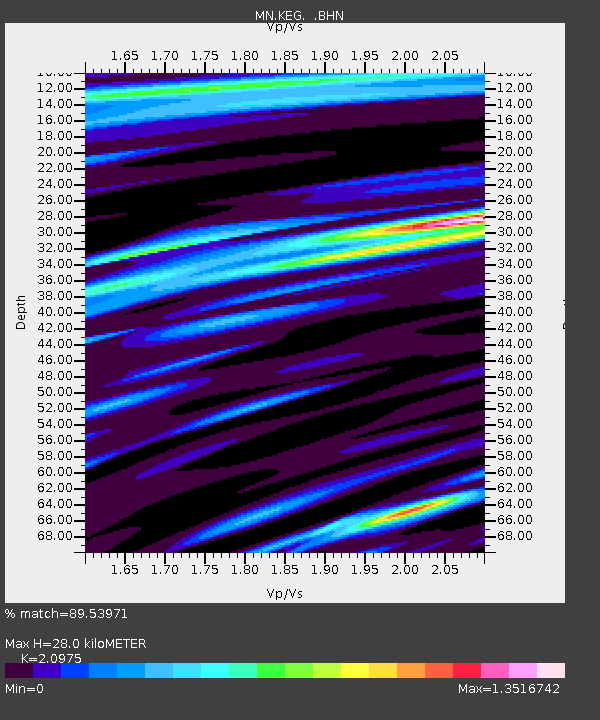
| Estimated Moho Depth: |
28.0 km |
| Estimated Crust Vp/Vs: |
2.10 |
| Assumed Crust Vp: |
6.312 km/s |
| Estimated Crust Vs: |
3.01 km/s |
| Estimated Crust Poisson's Ratio: |
0.35 |
|
| Radial Match: |
89.53971 % |
| Radial Bump: |
400 |
| Transverse Match: |
85.51251 % |
| Transverse Bump: |
400 |
| SOD ConfigId: |
6273 |
| Insert Time: |
2010-03-08 17:14:07.924 +0000 |
| GWidth: |
2.5 |
| Max Bumps: |
400 |
| Tol: |
0.001 |
|
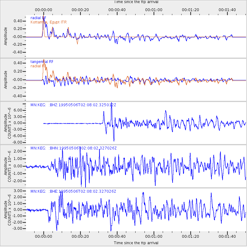
Signal To Noise
| Channel | StoN | STA | LTA |
| MN:KEG: :BHN:19950506T02:08:02.327026Z | 2.851782 | 2.3814974E-7 | 8.350909E-8 |
| MN:KEG: :BHE:19950506T02:08:02.327026Z | 10.036868 | 7.356585E-7 | 7.3295624E-8 |
| MN:KEG: :BHZ:19950506T02:08:02.325012Z | 32.470703 | 1.9227348E-6 | 5.921445E-8 |
| Arrivals |
| Ps | 5.1 SECOND |
| PpPs | 13 SECOND |
| PsPs/PpSs | 18 SECOND |


