You are here: Home > Network List > GS - US Geological Survey Networks Stations List
> Station OK051 E0350 and S34600 Roads, Ralston, OK > Earthquake Result Viewer
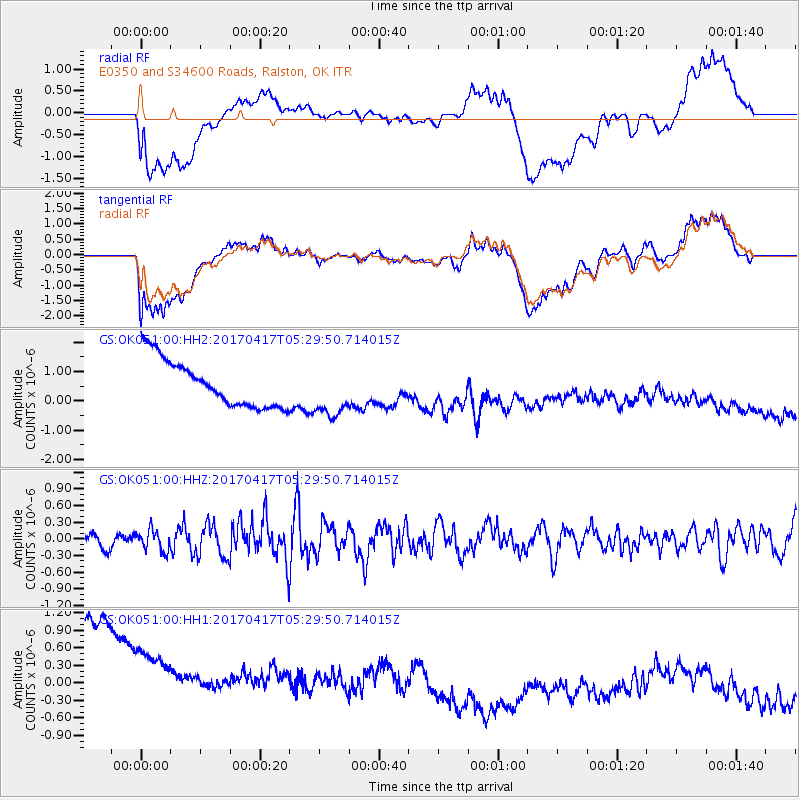
OK051 E0350 and S34600 Roads, Ralston, OK - Earthquake Result Viewer
*The percent match for this event was below the threshold and hence no stack was calculated.
| Earthquake location: |
Leeward Islands |
| Earthquake latitude/longitude: |
17.5/-61.1 |
| Earthquake time(UTC): |
2017/04/17 (107) 05:23:15 GMT |
| Earthquake Depth: |
21 km |
| Earthquake Magnitude: |
5.6 Mww |
| Earthquake Catalog/Contributor: |
NEIC PDE/us |
|
| Network: |
GS US Geological Survey Networks |
| Station: |
OK051 E0350 and S34600 Roads, Ralston, OK |
| Lat/Lon: |
36.51 N/96.84 W |
| Elevation: |
263 m |
|
| Distance: |
36.7 deg |
| Az: |
308.205 deg |
| Baz: |
111.433 deg |
| Ray Param: |
$rayparam |
*The percent match for this event was below the threshold and hence was not used in the summary stack. |
|
| Radial Match: |
38.080868 % |
| Radial Bump: |
400 |
| Transverse Match: |
33.622997 % |
| Transverse Bump: |
400 |
| SOD ConfigId: |
2028011 |
| Insert Time: |
2017-05-01 05:24:50.495 +0000 |
| GWidth: |
2.5 |
| Max Bumps: |
400 |
| Tol: |
0.001 |
|
Signal To Noise
| Channel | StoN | STA | LTA |
| GS:OK051:00:HHZ:20170417T05:29:50.714015Z | 1.671119 | 1.8537533E-7 | 1.1092886E-7 |
| GS:OK051:00:HH1:20170417T05:29:50.714015Z | 0.7023494 | 1.954137E-6 | 2.782286E-6 |
| GS:OK051:00:HH2:20170417T05:29:50.714015Z | 1.1393491 | 9.079743E-7 | 7.969237E-7 |
| Arrivals |
| Ps | |
| PpPs | |
| PsPs/PpSs | |


