You are here: Home > Network List > MN - MEDNET Project Stations List
> Station KEG Kottamya, Egypt > Earthquake Result Viewer
KEG Kottamya, Egypt - Earthquake Result Viewer
| Earthquake location: |
Kuril Islands |
| Earthquake latitude/longitude: |
44.3/149.8 |
| Earthquake time(UTC): |
1995/12/10 (344) 22:23:14 GMT |
| Earthquake Depth: |
33 km |
| Earthquake Magnitude: |
5.6 MB, 6.4 MS |
| Earthquake Catalog/Contributor: |
WHDF/NEIC |
|
| Network: |
MN MEDNET Project |
| Station: |
KEG Kottamya, Egypt |
| Lat/Lon: |
29.93 N/31.83 E |
| Elevation: |
460 m |
|
| Distance: |
86.9 deg |
| Az: |
309.833 deg |
| Baz: |
39.408 deg |
| Ray Param: |
0.043653134 |
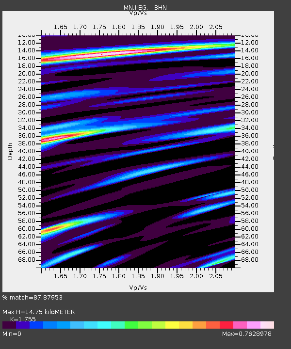
| Estimated Moho Depth: |
14.75 km |
| Estimated Crust Vp/Vs: |
1.75 |
| Assumed Crust Vp: |
6.312 km/s |
| Estimated Crust Vs: |
3.597 km/s |
| Estimated Crust Poisson's Ratio: |
0.26 |
|
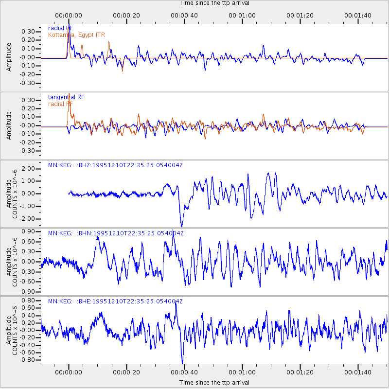
| Radial Match: |
87.87953 % |
| Radial Bump: |
400 |
| Transverse Match: |
65.72292 % |
| Transverse Bump: |
400 |
| SOD ConfigId: |
6273 |
| Insert Time: |
2010-03-08 17:14:19.966 +0000 |
| GWidth: |
2.5 |
| Max Bumps: |
400 |
| Tol: |
0.001 |
|
Signal To Noise
| Channel | StoN | STA | LTA |
| MN:KEG: :BHN:19951210T22:35:25.054004Z | 0.9914756 | 1.5912164E-7 | 1.6048973E-7 |
| MN:KEG: :BHE:19951210T22:35:25.054004Z | 0.97248644 | 1.2000493E-7 | 1.2340011E-7 |
| MN:KEG: :BHZ:19951210T22:35:25.054004Z | 4.0670185 | 4.258432E-7 | 1.0470649E-7 |
| Arrivals |
| Ps | 1.8 SECOND |
| PpPs | 6.3 SECOND |
| PsPs/PpSs | 8.1 SECOND |


